Microsoft Launches New Drone Simulator | Aero-News Network
Aero-News Network
RSS icon RSS feed
podcast icon MP3 podcast
Subscribe Aero-News e-mail Newsletter Subscribe

Airborne Unlimited -- Most Recent Daily Episodes

Episode Date

Airborne-Monday

Airborne-Tuesday

Airborne-Wednesday Airborne-Thursday

Airborne-Friday

Airborne On YouTube

Airborne-Unlimited-04.29.24

Airborne-Unlimited-04.23.24

Airborne-Unlimited-04.24.24 Airborne-FltTraining-04.25.24

Airborne-Unlimited-04.26.24

Fri, Feb 17, 2017

Microsoft Launches New Drone Simulator

Open-Source Software Free To Download

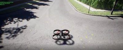
Microsoft has just published an open-source drone simulator to help designers develop UAVs without risking damage to expensive prototypes.

According to Microsoft, the The Aerial Informatics and Robotics platform solves for these two problems: the large data needs for training, and the ability to debug in a simulator. It will provide realistic simulation tools for designers and developers to seamlessly generate the copious amounts of training data they need. In addition, the platform leverages recent advances in physics and perception computation to create accurate, real-world simulations. Together, this realism, based on efficiently generated ground truth data, enables the study and execution of complex missions that might be time-consuming and/or risky in the real-world. For example, collisions in a simulator cost virtually nothing, yet provide actionable information for improving the design.

The platform enables easy interfaces to common robotic platforms such as a Robot Operating System (ROS) and comes pre-loaded with commonly used aerial robotic models and several sensors. In addition, the platform enables high-frequency simulations with support for hardware-in-the-loop (HIL) as well as software-in-the-loop (SIL) simulations with widely supported protocols (e.g. MavLink). Its cross-platform (Linux and Windows), open-source architecture is easily extensible to accommodate diverse new types of autonomous vehicles, hardware platforms, and software protocols. All this machinery allows users to quickly add custom robot models and new sensors to the simulator.

The platform is also designed to integrate with existing machine learning frameworks to generate new algorithms for perception and control tasks. Methods such as reinforcement and imitation learning, learning-by-demonstration, and transfer learning can leverage simulations and synthetically generated experiences to build realistic models.

Quadrotors are the first vehicles to have been implemented in the platform. These aerial robots have application in precision agriculture, pathogen surveillance, weather monitoring and more. A camera is an integral part of these systems and often the only way for a quadrotor to perceive the world to plan and execute its mission safely.

Microsoft says that the open-source, high-fidelity physics and photo-realistic robot simulator can help verify control and perception software, so that robot designers and developers can transfer their creations to the real world with the fewest possible changes.

It is available for download on GitHub.

(Images provided by Microsoft)

FMI: Download

Advertisement

More News

Unfortunate... ANN/SportPlane Resource Guide Adds To Cautionary Advisories

The Industry Continues to be Rocked By Some Questionable Operations Recent investigations and a great deal of data has resulted in ANN’s SportPlane Resource Guide’s rep>[...]

ANN FAQ: Turn On Post Notifications

Make Sure You NEVER Miss A New Story From Aero-News Network Do you ever feel like you never see posts from a certain person or page on Facebook or Instagram? Here’s how you c>[...]

ANN's Daily Aero-Term (04.29.24): Visual Approach Slope Indicator (VASI)

Visual Approach Slope Indicator (VASI) An airport lighting facility providing vertical visual approach slope guidance to aircraft during approach to landing by radiating a directio>[...]

ANN's Daily Aero-Term (04.28.24): Airport Marking Aids

Airport Marking Aids Markings used on runway and taxiway surfaces to identify a specific runway, a runway threshold, a centerline, a hold line, etc. A runway should be marked in ac>[...]

ANN's Daily Aero-Linx (04.28.24)

Aero Linx: The Skyhawk Association The Skyhawk Association is a non-profit organization founded by former Skyhawk Pilots which is open to anyone with an affinity for the A-4 Skyhaw>[...]

blog comments powered by Disqus


Advertisement

Advertisement

Podcasts

Advertisement

© 2007 - 2024 Web Development & Design by Pauli Systems, LC