 As ANN reported over the
weekend, Retired USAF Lt. Gen. Harry Goodall (pictured
at bottom right of story) died when the small aircraft he was
piloting crashed shortly after takeoff from McGregor Municipal
Airport around 8:00am September 2, 2006. He was the sole occupant
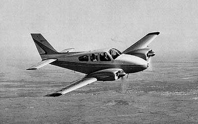
of the Beech Baron (file photo, below) he shared with a number of
co-owners. The NTSB has filed a preliminary report on the tragedy
that robbed the aviation community of a true American hero...
As ANN reported over the
weekend, Retired USAF Lt. Gen. Harry Goodall (pictured
at bottom right of story) died when the small aircraft he was
piloting crashed shortly after takeoff from McGregor Municipal
Airport around 8:00am September 2, 2006. He was the sole occupant
of the Beech Baron (file photo, below) he shared with a number of
co-owners. The NTSB has filed a preliminary report on the tragedy
that robbed the aviation community of a true American hero...
NTSB Identification: DFW06FA205
14 CFR Part 91: General Aviation
Accident occurred Saturday, September 02, 2006 in McGregor,
TX
Aircraft: Beech BE95 A-55, registration: N181Y
Injuries: 1 Fatal.
This is preliminary information, subject to change, and may
contain errors. Any errors in this report will be corrected when
the final report has been completed.
On September 2, 2006, approximately 0755 central daylight time,
a twin-engine Beech BE95 A-55 airplane, N181Y, was destroyed when
it impacted terrain following a loss of control during takeoff
initial climb from the McGregor Municipal Airport (PWG), near
McGregor, Texas. The airplane was registered to a private
individual and the pilot. The instrument rated commercial pilot,
sole occupant of the airplane, was fatally injured. Visual
meteorological conditions prevailed and an instrument flight plan
was filed for the 14 Code of Federal Regulations Part 91 personal
flight. The 525-nautical mile cross-country flight was originating
at the time of the accident and was destined for Norfolk, Virginia,
with an intermediate fuel stop at the Northwest Alabama Regional
Airport (MSL), near Muscle Shores, Alabama.
Several witnesses located adjacent to the accident site reported
observing the accident and were interviewed by the Safety Board
investigator-in-charge (IIC).
 The first witness, who
was driving westbound on Highway 84 in front of a convenience store
near PWG, reporting that he observed an airplane at a low altitude
in a slightly nose high attitude. The witness stated that the
airplane suddenly pitched upwards and rolled into a very steep left
turn. The airplane continued to descend into terrain in a left wing
low attitude and subsequently "bursted into flames." The witness
added that he initially thought the airplane was a "crop duster"
and at no time did the airplane cross south of Highway 84.
The first witness, who
was driving westbound on Highway 84 in front of a convenience store
near PWG, reporting that he observed an airplane at a low altitude
in a slightly nose high attitude. The witness stated that the
airplane suddenly pitched upwards and rolled into a very steep left
turn. The airplane continued to descend into terrain in a left wing
low attitude and subsequently "bursted into flames." The witness
added that he initially thought the airplane was a "crop duster"
and at no time did the airplane cross south of Highway 84.
A second witness, who was also driving westbound on Highway 84
reported observing the airplane take off and was climbing out when
the airplane "went into a hard bank to the left" and impacted the
ground left wing first. The witness added that he did not see any
smoke or flames originating from the airplane prior to it impacting
the ground. After the airplane impacted the ground, the airplane
caught on fire and continued to skid across the open field
A third witness, who was a professional pilot for a freight
company had landed on runway 17 and observed the accident airplane
holding short of the runway. The pilot rated witness reported that
while taxiing to the ramp of the airport, he observed the airplane
performing a normal climb out at 200 feet above ground level (agl)
when the airplane suddenly pitched upward and into a steep roll to
the left. The witness stated that at no time did the airplane cross
south of Highway 84 and did not appear like he was turning around.
The witness added that he did not see the actual impact with the
ground due to a hangar obstructing his view, but did see the
airplane trying to level the wings seconds before impact. The
witness heard no radio communications on the Unicom frequency from
the accident airplane.
According to employees at the Fixed Base Operator (FBO) at PWG,
no radio communications were received by the pilot of the accident
airplane on the Common Traffic Advisory Frequency (CTAF) of 122.80
megahertz (mHz).
 The co-owner of the
airplane reported that the FBO refueled the airplane the day prior
to the accident. All four fuel tanks were reported to have been
"topped" off with 100LL aviation fuel. A flight line technician,
who refueled the airplane the day prior of the accident, was
interviewed by the IIC. The line technician confirmed that all four
fuel tanks were topped-off. The FBO verified that the BP fuel
station sump and vessels were free of debris and fuel samples that
were extracted were bright and clean on September 6, 2006. The
refueling truck that was used to refuel the airplane was also
examined and a sample was extracted. The fuel sample was bright and
clean. Also, the truck filter was found to be free of debris.
The co-owner of the
airplane reported that the FBO refueled the airplane the day prior
to the accident. All four fuel tanks were reported to have been
"topped" off with 100LL aviation fuel. A flight line technician,
who refueled the airplane the day prior of the accident, was
interviewed by the IIC. The line technician confirmed that all four
fuel tanks were topped-off. The FBO verified that the BP fuel
station sump and vessels were free of debris and fuel samples that
were extracted were bright and clean on September 6, 2006. The
refueling truck that was used to refuel the airplane was also
examined and a sample was extracted. The fuel sample was bright and
clean. Also, the truck filter was found to be free of debris.
According to the Federal Aviation Administration (FAA), an
instrument flight plan was filed but not activated prior to the
flight. According to the filed flight plan, the proposed departure
time was 0800 and 7,000 feet was requested for an initial altitude,
at a proposed true airspeed of 185 knots. The pilot had estimated
arriving at MSL at 1058.
The airplane impacted a freshly plowed field approximately 0.17
miles on a heading of 119 degrees from the departure end of runway
17. The Global Positioning System (GPS) coordinates recorded at the
accident site using a hand held GPS unit were latitude 31 degrees
28.657 minutes North and longitude 097 degrees 18.926 minutes West
at a field elevation of 590 feet mean sea level. The wreckage
energy path measured approximately 172 feet in length, oriented on
a magnetic heading of 045 degrees.
 Examination of the
wreckage revealed that all aircraft components were located at the
accident site. The landing gear and flaps were found in the
retracted position. Flight control continuity was established
throughout the airplane to the ailerons, rudder, and elevator from
the center section of the fuselage.
Examination of the
wreckage revealed that all aircraft components were located at the
accident site. The landing gear and flaps were found in the
retracted position. Flight control continuity was established
throughout the airplane to the ailerons, rudder, and elevator from
the center section of the fuselage.
At 0755, the automated surface observation system at PWG
reported wind from 140 degrees at 8 knots, visibility 10 statute
miles, few clouds at 4,000 feet, few clouds at 4,800 feet,
scattered clouds at 7,000 feet, temperature 26 degrees Celsius, dew
point 21 degrees Celsius, and an altimeter setting of 29.97 inches
of Mercury.
The airplane and engines were recovered to Air Salvage of
Dallas, near Lancaster, Texas, for further examination.
 ANN's Daily Aero-Linx (05.04.24)

