Tue, Nov 23, 2010
Unavailable Or Unreliable Signals Possible Through December
9
 The FAA is continuing its GPS testing in an area that may
affect the reliability of GPS signals in several western states
from California to Idaho, western Colorado and Wyoming. The
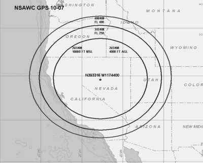
testing is Centered at 393316N/1174400W or the BAM VOR 211.7 degree
radial at 71.4NM.
The FAA is continuing its GPS testing in an area that may
affect the reliability of GPS signals in several western states
from California to Idaho, western Colorado and Wyoming. The
testing is Centered at 393316N/1174400W or the BAM VOR 211.7 degree
radial at 71.4NM.
GPS testing scheduled from November 22nd through December 9th,
2010 as following:
22 NOV 2100Z – 23 NOV 0445Z
23 NOV 1700Z – 24 NOV 0030Z
29 NOV 2100Z – 30 NOV 0445Z
30 NOV 1600Z – 30 NOV 2359Z
01 DEC 2301Z – 02 DEC 0445Z
02 DEC 1600Z – 02 DEC 2359Z
03 DEC 0130Z – 03 DEC 0330Z
03 DEC 1300Z – 03 DEC 2100Z
07 DEC 1300Z – 07 DEC 2359Z
08 DEC 1200Z – 09 DEC 0530Z
Pilots are advised to check NOTAMs frequently for possible
changes prior to operating in the area. Times listed are GMT. The
test will be conducted in continuous blocks throughout the period
outlined, and the FAA says the GPS signal may be unreliable or
unavailable within an area centered at
393316N/1174400W or the BAM VOR 211.7 degree radial at 71.4NM out
to a distance of 400NM at FL400, decreasing in area with a decrease
in altitude to an area with a radius of 345NM at FL250, an area
with a radius of 265NM at 10,000FT MSL and an area with a radius of
265NM at 4,000FT AGL.
The agency asks that any aircraft unable to navigate due to loss
of GPS is requested to advise ATC for additional assistance. Pilots
should report anomalies during testing to the appropriate ATC
Facility to assist in the determination of the extent of GPS
degradation during tests. When making such a report, pilots are
asked to include their aircraft call sign and type, as well as
location, altitude, date and time of occurrence and remarks, such
as how testing impacted aircraft navigation.
The NOTAM indicates that the impacted ARTCCs are ZSE, ZLC, ZDV,
ZOA, ZIA and ZAB. The NOTAMs discussed in this advisory may change
with little or no notice. Pilots are advised to check NOTAMs
frequently for possible changes prior to operations in the area.
The FAA says NOTAMs will be published at least 72 hours in advance
of any GPS tests.
More News
Aero Linx: JAARS Nearly 1.5 billion people, using more than 5,500 languages, do not have a full Bible in their first language. Many of these people live in the most remote parts of>[...]
'Airplane Bounced Twice On The Grass Runway, Resulting In The Nose Wheel Separating From The Airplane...' Analysis: The pilot reported, “upon touchdown, the plane jumped back>[...]
"Burt is best known to the public for his historic designs of SpaceShipOne, Voyager, and GlobalFlyer, but for EAA members and aviation aficionados, his unique concepts began more t>[...]
"Polaris Dawn, the first of the program’s three human spaceflight missions, is targeted to launch to orbit no earlier than summer 2024. During the five-day mission, the crew >[...]
There Are SO Many Ways To Get YOUR Aero-News! It’s been a while since we have reminded everyone about all the ways we offer your daily dose of aviation news on-the-go...so he>[...]
 ANN's Daily Aero-Linx (05.04.24)

