Delta II Launches New GPS Satellite Into Orbit | Aero-News Network
Aero-News Network
RSS icon RSS feed
podcast icon MP3 podcast
Subscribe Aero-News e-mail Newsletter Subscribe

Airborne Unlimited -- Most Recent Daily Episodes

Episode Date

Airborne-Monday

Airborne-Tuesday

Airborne-Wednesday Airborne-Thursday

Airborne-Friday

Airborne On YouTube

Airborne-Unlimited-04.29.24

Airborne-Unlimited-04.23.24

Airborne-Unlimited-04.24.24 Airborne-FltTraining-04.25.24

Airborne-Unlimited-04.26.24

Fri, Apr 04, 2003

Delta II Launches New GPS Satellite Into Orbit

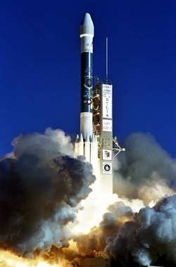
A Delta II, carrying a new Global Positioning System satellite, launched from Cape Canaveral, March 31.

The GPS IIR-9 was launched aboard a Delta II launch vehicle from Space Launch Complex 17A, Cape Canaveral Air Force Station, Fl. The rocket lifted off at 5:09 p.m. EST and the 68-minute mission ended with the successful delivery of the spacecraft to the targeted orbit.

“Today’s launch was the culmination of a dedicated effort for mission success by our government and industry team,” said Jay Witzling, vice president, Delta Programs. “We recognize the importance of this mission to our customer and the nation.”

GPS provides military and civilian users with three-dimensional position location data in longitude, latitude and elevation as well as precise time and velocity. The GPS system is operated by the US Air Force Space Command.

In the first six days of Operation Iraqi Freedom, more than 80 percent of the munitions that hit several thousand targets were precision-guided. A GPS satellite emits a continuous navigation signal and orbits Earth every 12 hours. The system is so accurate that time can be figured to within 25 billionths of a second, velocity within a fraction of a mile per hour and location to within 16 meters, or about 52 feet. The next scheduled Delta launch is the Space Infrared Telescope Facility, or SIRTF, mission for NASA in mid-April from Cape Canaveral aboard the first launch of the Delta II Heavy configuration.

FMI: www.boeing.com, www.nasa.gov, www.af.mil

Advertisement

More News

Unfortunate... ANN/SportPlane Resource Guide Adds To Cautionary Advisories

The Industry Continues to be Rocked By Some Questionable Operations Recent investigations and a great deal of data has resulted in ANN’s SportPlane Resource Guide’s rep>[...]

ANN FAQ: Turn On Post Notifications

Make Sure You NEVER Miss A New Story From Aero-News Network Do you ever feel like you never see posts from a certain person or page on Facebook or Instagram? Here’s how you c>[...]

ANN's Daily Aero-Term (04.29.24): Visual Approach Slope Indicator (VASI)

Visual Approach Slope Indicator (VASI) An airport lighting facility providing vertical visual approach slope guidance to aircraft during approach to landing by radiating a directio>[...]

ANN's Daily Aero-Term (04.28.24): Airport Marking Aids

Airport Marking Aids Markings used on runway and taxiway surfaces to identify a specific runway, a runway threshold, a centerline, a hold line, etc. A runway should be marked in ac>[...]

ANN's Daily Aero-Linx (04.28.24)

Aero Linx: The Skyhawk Association The Skyhawk Association is a non-profit organization founded by former Skyhawk Pilots which is open to anyone with an affinity for the A-4 Skyhaw>[...]

blog comments powered by Disqus


Advertisement

Advertisement

Podcasts

Advertisement

© 2007 - 2024 Web Development & Design by Pauli Systems, LC