New Project Will Provide Single View Of Air Traffic Trajectories In Europe | Aero-News Network
Aero-News Network
RSS icon RSS feed
podcast icon MP3 podcast
Subscribe Aero-News e-mail Newsletter Subscribe

Airborne Unlimited -- Most Recent Daily Episodes

Episode Date

Airborne-Monday

Airborne-Tuesday

Airborne-Wednesday Airborne-Thursday

Airborne-Friday

Airborne On YouTube

Airborne-Unlimited-04.29.24

Airborne-Unlimited-04.23.24

Airborne-Unlimited-04.24.24 Airborne-FltTraining-04.25.24

Airborne-Unlimited-04.26.24

Wed, Nov 29, 2017

New Project Will Provide Single View Of Air Traffic Trajectories In Europe

Will Result In More Predictable And Punctual Flights

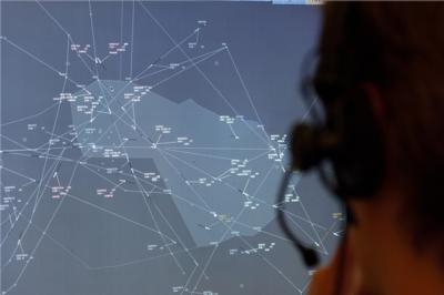
A European project is developing solutions and procedures to provide one single and precise view of air traffic movements across the continent. The Four Dimensions Trajectory Management (4DTM) project is addressing one of the key challenges for advancing the Single European Sky: guaranteeing that navigation service providers, airport operators, airlines and the aviation community at large share a single harmonized view that is updated in real time with the movements of both civil and military aircraft throughout Europe.

The project is run within the framework of SESAR, the technological pillar Single European Sky, and is funded under the EU’s Horizon 2020 research and innovation program. Led by Indra, the project consortium is comprised of 28 participants including navigation service providers, technology companies and research bodies from European Union, Norway and Switzerland.

The core characteristic of 4D is that trajectories are always synchronised between air and ground systems in every moment of its route. The project will use data from each country's air traffic ground control centers, the European Network Manager - the body that supervises all of Europe's air traffic-, and airport operators. It will also process data on trajectories handled by the aircraft themselves and data used for flight planning by airlines’ flight operations centre. Likewise, information on military flights will also be used in order to better evaluate the impact on civil traffic.

Not only with will the project synchronize flight trajectory data, it will also develop new tools to improve the availability of precise and harmonised aeronautical and meteorological information. Doing so will enable the detection in advance, of any unexpected situations that may generate delays and require adjusting scheduled operations.

The solution paves the way for the definitive implementation of flights using 4D trajectories across the entire continent. This new way of flying allows aircraft to select direct routes, thereby reducing fuel consumption, CO2 emissions and costs. Furthermore, controllers will have available more precise information for planning operations and managing traffic more smoothly, and will be to respond to the expected increase of traffic in the coming years. Finally, improving Europe's transportation efficiency will not only directly result in cost savings, but will also improve the environment and airline passenger convenience, while directly impacting the economic growth of the entire continent.

The objectives of SESAR are to enable a threefold increase in traffic management capacity across Europe, improve safety by a factor of 10, reduce the environmental impact by 10%, and cut the costs of air traffic management services by 50%.

Only by modernizing systems and air operations will Europe be able to keep pace with the constant annual increases in air traffic. Flights are forecast to rise from 10 million per year at present to 16.9 million by 2030.

(Image provided with Indra news release)

FMI: www.sesarju.eu

Advertisement

More News

Unfortunate... ANN/SportPlane Resource Guide Adds To Cautionary Advisories

The Industry Continues to be Rocked By Some Questionable Operations Recent investigations and a great deal of data has resulted in ANN’s SportPlane Resource Guide’s rep>[...]

ANN FAQ: Turn On Post Notifications

Make Sure You NEVER Miss A New Story From Aero-News Network Do you ever feel like you never see posts from a certain person or page on Facebook or Instagram? Here’s how you c>[...]

ANN's Daily Aero-Term (04.29.24): Visual Approach Slope Indicator (VASI)

Visual Approach Slope Indicator (VASI) An airport lighting facility providing vertical visual approach slope guidance to aircraft during approach to landing by radiating a directio>[...]

ANN's Daily Aero-Term (04.28.24): Airport Marking Aids

Airport Marking Aids Markings used on runway and taxiway surfaces to identify a specific runway, a runway threshold, a centerline, a hold line, etc. A runway should be marked in ac>[...]

ANN's Daily Aero-Linx (04.28.24)

Aero Linx: The Skyhawk Association The Skyhawk Association is a non-profit organization founded by former Skyhawk Pilots which is open to anyone with an affinity for the A-4 Skyhaw>[...]

blog comments powered by Disqus


Advertisement

Advertisement

Podcasts

Advertisement

© 2007 - 2024 Web Development & Design by Pauli Systems, LC