WorldWide Telescope Provides Detailed View Of Martian
Surface
NASA and Microsoft Research are bringing Mars to life with new
features in the WorldWide Telescope software that provide viewers
with a high-resolution 3-D map of the Red Planet.

Microsoft's online virtual telescope explores the universe using
images NASA spacecraft return from other worlds. Teams at NASA's
Ames Research Center in Moffett Field, CA, and Microsoft in
Redmond, WA, jointly developed the software necessary to make
NASA's planetary data available in WorldWide Telescope.
"By providing the Mars dataset to the public on the WorldWide
Telescope platform, we are enabling a whole new audience to
experience the thrill of space," said Chris C. Kemp, chief
technology officer for information technology at NASA Headquarters
in Washington.
The fully-interactive images and new NASA data will allow
viewers to virtually explore Mars and make their own scientific
discoveries. New features include the highest resolution fully
interactive map of Mars ever created, realistic 3-D renderings of
the surface of the planet and video tours with two NASA scientists,
James Garvin of NASA's Goddard Space Flight Center in Greenbelt,
MD, and Carol Stoker of Ames.
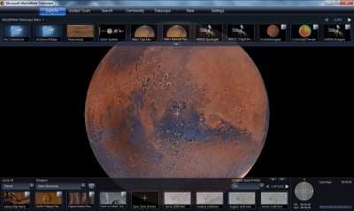
Screen Shot
Garvin's tour walks viewers through the geological history of
Mars and discusses three possible landing sites for human missions
there. Each landing site highlights a different geological era of
the planet. Stoker's tour addresses the question "Is there life on
Mars?" and describes the findings of NASA's Mars Phoenix
Lander.
"Our hope is that this inspires the next generation of explorers
to continue the scientific discovery process," said Ames Center
Director S. Pete Worden.
The Intelligent Robotics Group at Ames Research Center developed
open source software that runs on the NASA Nebula cloud computing
platform to create and host the high resolution maps. The maps
contain 74,000 images from Mars Global Surveyor's Mars Orbiter
Camera and more than 13,000 high-resolution images of Mars taken by
the Mars Reconnaissance Orbiter's High Resolution Imaging Science
Experiment (HiRISE) camera. Each individual HiRISE image contains
more than a billion pixels. The complete maps were rendered into
image mosaics containing more than half a billion smaller
images.

"These incredibly detailed maps will enable the public to better
experience and explore Mars," said Michael Broxton, a research
scientist in the Intelligent Robotics Group at Ames. "The
collaborative relationship between NASA and Microsoft Research was
instrumental for creating the software that brings these new Mars
images into people's hands, classrooms and living rooms."
NASA's Mars Reconnaissance Orbiter (MRO) reached the planet in
2006 to begin a two-year primary science mission. The mission has
returned more data about Mars than all other spacecraft sent to the
Red Planet. The Global Surveyor began orbiting Mars in 1997. The
spacecraft operated longer than any other Mars spacecraft, ceasing
operations in November 2006.
 Sierra Space Repositions Dream Chaser for First Mission

