Sport Pilot Tried To Land At Wrong Airport... At Night
 The National
Transportation Safety Board recently released its Preliminary
Report into the October 4 downing of a T-211 Thorpedo near Denton,
TX.
The National
Transportation Safety Board recently released its Preliminary
Report into the October 4 downing of a T-211 Thorpedo near Denton,
TX.
According to the report, the aircraft crashed while on approach
to land at Denton Municipal Airport (DTO) just before 2000 CDT,
approximately 20 minutes past the end of civil twilight. The pilot,
who was flying under a sport-pilot license -- and, thus, not
trained or cleared for nighttime flying -- told the agency he
became disoriented on a flight back from Granbury Municipal Airport
(GDJ), located southwest of the Dallas/Fort Worth metroplex, to
Grand Prairie Municipal (GPM).
The pilot and his passenger departed GPM at 1751 CDT. After
landing at Granbury, the aircraft departed under VFR conditions at
1905 intending to return to GPM. The pilot -- who admitted he had
never flown at night -- told the agency he began to "follow the
highway" back to GPM.
The pilot told the NTSB he saw a lake that resembled a body of
water near Grand Prairie, with an airport nearby. He entered the
traffic pattern at the airport, believing it to be GPM, and
attempted to activate the pilot-activated runway lights on the GPM
frequency. When the lights did not come on, he said, he realized he
was at the wrong airport.
Knowing he had to set down due to darkness, the pilot attempted
to land at Denton, located on the northwest end of the DFW
metroplex -- 31 nautical miles from Grand Prairie, which lies south
of D/FW International Airport.
As ANN reported, the pilot
and his son, who was celebrating his 16th birthday, were injured
when the aircraft impacted a field north of DTO. According to the
report, winds at DTO were from 130, at five knots.
Observations
(Editor's Note: The following is an
extrapolation of available data on the part of the ANN editorial
staff, and is not intended as a definitive explanation of the
sequence of events leading to the accident. The final cause, as
always, will be determined in the NTSB's Probable Cause
report.)
On first blush, it would be easy to chalk this accident up to
the fact the pilot was not familiar with -- or rated for --
nighttime flight. While the pilot admits he became disoriented due
to nighttime conditions, for which he was unprepared... this could
also serve as a cautionary tale for any pilot flying VFR in the
dark.

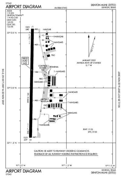
Despite the fact DTO lies 31 nautical miles north of GPM, it
isn't difficult to see how the pilot may have confused the two
airports. DTO and GPM share identical runway layouts (17/35, as
shown above) and are located near large lakes -- Joe Pool Lake and
Lake Lewisville, respectively. The two airports lie 55.1
and 44.8 nautical miles, respectively, from Granbury.
The pilot notes he tried to "follow the highway" back to Grand
Prairie. There is no direct highway linking the two communities.
The pilot may have intended to follow State Highway 377 northeast
to the junction with Interstate 20 west of Fort Worth, which in
turn runs to the south of GPM.
It's also possible the pilot became disoriented attempting to
pick out the correct highway from the lights of the large city...
and rather than picking up I-20 heading east, followed Interstate
35W -- which runs north almost in a direct line to Denton --
instead.
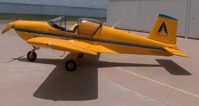
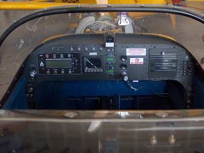
The accident aircraft -- N211LS, billed by the manufacturer as
the first US-built S-LSA to be awarded an FAA airworthiness
certificate -- was equipped with a single Dynon EFIS, but no
panel-mounted GPS, as shown in the image below. There was no
"Direct-To" option in the aircraft available to point the
pilot in the right direction.
We know the winds on the ground at DTO were light, from the SSE.
If similar conditions existed throughout the aircraft's route of
flight -- with stronger windspeeds at the altitude -- it may have
been enough to push the plane roughly in the direction of DTO, if
the pilot failed to hold the proper wind-correction angle.
Correcting for the wind is made more difficult in twilight
conditions, especially when over a large city with a lot of lights,
and few if any discernible landmarks. That's especially true if the
pilot was also feeling anxiety about making it back to GPM before
nighttime started.
Lastly, the NTSB notes the aircraft approach DTO from the north.
That area is largely agricultural, without benefit of city
lights... and as the moon was waning October 4, it's likely there
was very little available light to assist the pilot in determining
where the ground lay. The NTSB does not note if the pilot changed
to the Denton tower frequency... or, if he was able to bring up the
runway lights, and the VASI for runway 17... before attempting to
land.
 Unfortunate... ANN/SportPlane Resource Guide Adds To Cautionary Advisories

