Sentera Unlocks the Power Of Drone Data | Aero-News Network
Aero-News Network
RSS icon RSS feed
podcast icon MP3 podcast
Subscribe Aero-News e-mail Newsletter Subscribe

Airborne Unlimited -- Most Recent Daily Episodes

Episode Date

Airborne-Monday

Airborne-Tuesday

Airborne-Wednesday Airborne-Thursday

Airborne-Friday

Airborne On YouTube

Airborne-Unlimited-04.29.24

Airborne-Unlimited-04.23.24

Airborne-Unlimited-04.24.24 Airborne-FltTraining-04.25.24

Airborne-Unlimited-04.26.24

Thu, Oct 27, 2016

Sentera Unlocks the Power Of Drone Data

AgVault, OnTop Software Platforms Now Available At Tiered Subscription Levels

Sentera is enabling every drone user to unlock the power of their data by offering AgVault and OnTop Software Platforms at affordably-priced tiered subscription levels. An annual subscription is now offered at 79% price reduction, unlocking the power of drone data management for an even larger market segment.

"We have had an amazing response to both our AgVault and OnTop Software solutions. The tremendous response provided us with the ability to develop tiers and adjust our product pricing," said Greg Emerick, executive vice president of Business Development for Sentera. "Whether someone is looking to simply autonomously fly a drone and collect imagery, consult on a client's drone data, or immediately analyze true-NDVI data, AgVault and OnTop are positioned to help save every user both time and money."

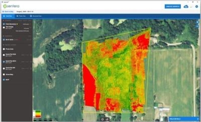
Sentera's game-changing software solutions, AgVault and OnTop, are enabling users to fly and capture precise data, and use that data to create crop health maps, analyze cellular broadcast towers – and so much more.

"Our offering enables customers to access revenue-driving analytics, consuming additional services on-demand while keeping the control of data and analysis in the customer's hands," noted Emerick.

"Reducing our annual Pro subscription to $250 opens up complete data control to a broader customer base," continued Emerick. "When developing our tiers, we recognized that some people simply want to consume data, or just fly a drone. We designed the Viewer, for $12 per month, and the Mobile App, for $5 per month, specifically with these two user groups in mind." 

Sentera's pricing and tiered subscription offerings come right on the heels of several recent feature enhancements. Some of the enhancements include:

Simple Field Splitting: Quickly divide fields or parcels of land that need special attention
Easy Image Omission: Easily exclude imagery that is irrelevant or out of a field boundary
Enhanced Color Mapping: Efficiently distinguish between healthy and stressed plants with more vibrant and normalized difference vegetation index (NDVI) color maps Wizard
Autonomous Flight Feature: Autonomously fly a DJI Inspire, Phantom 4, or Phantom 3 drone with an iOS smart device, ensuring the appropriate sideslip and overlap is captured for perfect images
Battery Swap Feature: Plan as many acres of flight as you have batteries. AgVault Mobile will note the precise location where the drone left for a battery swap, resuming image capture from exactly where it left off

AgVault and OnTop Software are each offered at three subscription tiers: Pro, Viewer, and Mobile respective subscription pricing of $29, $12, and $5 per month. An annual Pro subscription is offered at $250. 

(Image provided with Sentra news release)

FMI: www.sentera.com/agvault, www.sentera.com/ontop

Advertisement

More News

Unfortunate... ANN/SportPlane Resource Guide Adds To Cautionary Advisories

The Industry Continues to be Rocked By Some Questionable Operations Recent investigations and a great deal of data has resulted in ANN’s SportPlane Resource Guide’s rep>[...]

ANN FAQ: Turn On Post Notifications

Make Sure You NEVER Miss A New Story From Aero-News Network Do you ever feel like you never see posts from a certain person or page on Facebook or Instagram? Here’s how you c>[...]

ANN's Daily Aero-Term (04.29.24): Visual Approach Slope Indicator (VASI)

Visual Approach Slope Indicator (VASI) An airport lighting facility providing vertical visual approach slope guidance to aircraft during approach to landing by radiating a directio>[...]

ANN's Daily Aero-Term (04.28.24): Airport Marking Aids

Airport Marking Aids Markings used on runway and taxiway surfaces to identify a specific runway, a runway threshold, a centerline, a hold line, etc. A runway should be marked in ac>[...]

ANN's Daily Aero-Linx (04.28.24)

Aero Linx: The Skyhawk Association The Skyhawk Association is a non-profit organization founded by former Skyhawk Pilots which is open to anyone with an affinity for the A-4 Skyhaw>[...]

blog comments powered by Disqus


Advertisement

Advertisement

Podcasts

Advertisement

© 2007 - 2024 Web Development & Design by Pauli Systems, LC