Three Alaska-Based Campaigns Measuring A Variety Of Atmospheric Metrics
NASA researchers this summer and fall are carrying out three Alaska-based airborne research campaigns aimed at measuring greenhouse gas concentrations near Earth’s surface, monitoring Alaskan glaciers, and collecting data on Arctic sea ice and clouds.
The Arctic Radiation – IceBridge Sea and Ice Experiment, or ARISE, is a new NASA airborne campaign to collect data on thinning sea ice and measure cloud and atmospheric properties in the Arctic. The campaign was designed to address questions about the relationship between retreating sea ice and the Arctic climate.
Arctic sea ice reflects sunlight away from Earth, moderating warming in the region. Loss of sea ice means more heat from the sun is absorbed by the ocean surface, adding to Arctic warming. In addition, the larger amount of open water leads to more moisture in the air, which affects the formation of clouds that have their own effect on warming, either enhancing or reducing it.
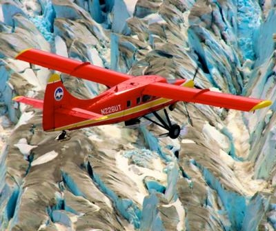
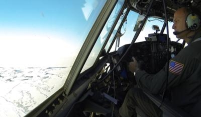
Changes in more than 130 Alaskan glaciers are being surveyed by scientists at the University of Alaska-Fairbanks in a DHC-3 Otter as part of NASA’s multi-year Operation IceBridge.
“ARISE will link clouds and sea ice in a way that improves our computer models of the Arctic,” said Tom Wagner, cryospheric sciences program manager at NASA Headquarters in Washington. “Our goal is to better understand both the causes of Arctic ice loss and the connections to the overall Earth system.”
The ARISE campaign, using NASA’s C-130 Hercules aircraft from Wallops Flight Facility in Virginia, had its first science flight on Sept. 4 and has already carried out several surveys of sea ice and cloud conditions. The campaign is based in Fairbanks, Alaska.
“We are off to a great start collecting a timely and unique dataset to help better understand the potential influence of clouds on the Arctic climate as sea ice conditions change,” said William Smith, ARISE principal investigator at NASA’s Langley Research Center in Hampton, Virginia.
CARVE, or Carbon in Arctic Reservoirs Vulnerability Experiment, is a five-year airborne research campaign that uses instruments aboard NASA aircraft to measure air and surface conditions and concentrations of gases like carbon dioxide, carbon monoxide and methane. Using NASA’s C-23 Sherpa aircraft, CARVE flies approximately two weeks per month from May to November. Now that the mission is in its fourth year, researchers are building a detailed picture of how the land and atmosphere interact in the Arctic.
In high-latitude areas like Alaska, frozen ground known as permafrost can trap large amounts of carbon dioxide and methane produced by layers of decayed plant and animal matter. As permafrost temperatures have been increasing faster than air temperatures in the Arctic, scientists have questioned whether these heat-trapping gases could be released into the atmosphere, increasing their global concentrations.
“The exchange of carbon between the land and the atmosphere is very important – but uncertain,” said Charles Miller, a scientist at NASA’s Jet Propulsion Laboratory in Pasadena, California, and principal investigator of CARVE.
Another area of interest in Alaska is its glaciers. Researchers at the University of Alaska Fairbanks have been taking airborne measurements of glacier surface height using a laser altimeter, an instrument that bounces a laser off of the ice surface and measures how long it takes to return. These flights are part of NASA’s Operation IceBridge, an airborne campaign that studies changes to land and sea ice in the Arctic and Antarctic.
University researchers observe Alaskan glaciers twice a year, before and after the melt season, to determine how much ice they have lost or gained. The scientists have surveyed between 130 and 140 glaciers going back to the mid-1990s. IceBridge’s Alaska flights have found that glaciers across the state are declining rapidly, with those terminating on land and in lakes losing mass faster than expected.
Researchers are also finding that there is considerable variation in mass loss throughout Alaska. “One glacier might be doing better than the one next to it,” said Evan Burgess, University of Alaska Fairbanks scientist and member of the IceBridge Alaska team.
NASA monitors Earth's vital signs from land, air and space with a fleet of satellites and ambitious airborne and ground-based observation campaigns. NASA develops new ways to observe and study Earth's interconnected natural systems with long-term data records and computer analysis tools to better see how our planet is changing. The agency shares this unique knowledge with the global community and works with institutions in the United States and around the world that contribute to understanding and protecting our home planet.
(Images provided by NASA)
 Unfortunate... ANN/SportPlane Resource Guide Adds To Cautionary Advisories

