Fri, Sep 05, 2008
Free TIS-B, FIS-B Available To Pilots With Equipped Planes
The FAA announced Thursday that pilots flying in aircraft
equipped with Automatic Dependent Surveillance-Broadcast (ADS-B)
avionics in South Florida now receive free traffic and weather
information on their cockpit displays. This marks the first time
area pilots are able see the same traffic information that's seen
by air traffic controllers.
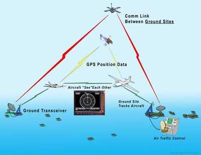
The display of traffic information (called Traffic Information
Service-Broadcast, or TIS-B) and weather information (Flight
Information Service-Broadcast, or FIS-B) was made possible by the
installation of 11 ground stations in South Florida by ITT Corp.
The ground stations transmit satellite signals showing aircraft
locations to pilots and controllers.
Flight information now being broadcast free to pilots includes
graphical displays of weather tracked by the National Weather
Service and essential flight information, including special-use
airspace and temporary flight restrictions.
The agency says it's is on track in its aggressive plan to
deploy ADS-B nationwide, beginning in Florida. Full commissioning
of broadcast services in Florida is scheduled for November. Once
commissioning takes place, ground stations will start transmitting
as soon they are installed and readied for service.
ADS-B ground stations providing both TIS-B and FIS-B services
will be deployed along the East and West Coasts, areas of the
Midwest and portions of Alaska by 2010. By 2013, ADS-B coverage
will be in place everywhere the FAA now provides radar coverage.
There will also be coverage in places where radars can’t be
deployed, such as the Gulf of Mexico.
ITT was awarded the national contract to establish the ground
infrastructure for ADS-B a year ago. The 11 sites in Southern
Florida are at Lakeland Linder Regional Airport, Hardee,
Okeechobee, Dade-Collier Airport, Key West, St. Cloud, Sebastian
Municipal Airport, Hobe Sound, Boca Raton Airport, Homestead Dade
Marina and Florida Keys Marathon Airport.
More News
Airport Marking Aids Markings used on runway and taxiway surfaces to identify a specific runway, a runway threshold, a centerline, a hold line, etc. A runway should be marked in ac>[...]
"It is extremely difficult, if not impossible, for manned aircraft to see a drone while conducting crop-enhancing and other aerial applications at low altitudes and high speeds. We>[...]
Aero Linx: The Skyhawk Association The Skyhawk Association is a non-profit organization founded by former Skyhawk Pilots which is open to anyone with an affinity for the A-4 Skyhaw>[...]
“The T-54A benefits from an active Beechcraft King Air assembly line in Wichita, Kansas, where all required METS avionics and interior modifications are installed on the line>[...]
Aero Linx: Aerostar Owners Association The Association offers the Aerostar Owner a unique opportunity to tap an invaluable source of information concerning the care and feeding of >[...]
 ANN's Daily Aero-Term (04.28.24): Airport Marking Aids

