PC Aviator Launches MegaSceneryEarth For FSX | Aero-News Network
Aero-News Network
RSS icon RSS feed
podcast icon MP3 podcast
Subscribe Aero-News e-mail Newsletter Subscribe

Airborne Unlimited -- Most Recent Daily Episodes

Episode Date

Airborne-Monday

Airborne-Tuesday

Airborne-Wednesday Airborne-Thursday

Airborne-Friday

Airborne On YouTube

Airborne-Unlimited-04.22.24

Airborne-Unlimited-04.16.24

Airborne-FlightTraining-04.17.24 Airborne-AffordableFlyers-04.18.24

Airborne-Unlimited-04.19.24

Sat, Dec 27, 2008

PC Aviator Launches MegaSceneryEarth For FSX

Hyper-Realistic Photo-Scenery On-Demand

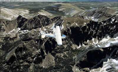
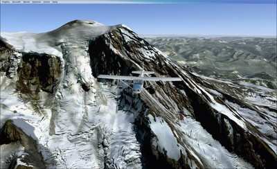
MegaScenery publisher PC Aviator, in partnership with MegaScenery developer Aerosoft Australia Pty Ltd, announced Friday the launch of the next evolutionary phase of the MegaScenery brand -- MegaSceneryEarth.

MegaSceneryEarth is a product line that involves the massive project of mapping as much of the earth as possible as ready-to-use photoscenery (created from aerial photography) for Microsoft Flight Simulator X. The focus initially will be on the continental USA.

End users visit the MegaSceneryEarth website, choose the pre-created areas of photoscenery packaged as tiles varying between 1200 and 2800 square miles and download them instantly after purchase.

While the concept of downloaded software is certainly not new, the concept of a megastore of on-demand, ready-to-use photoscenery for Microsoft Flight Simulator available for instant download is as a result of the MegaSceneryEarth model.

Aerial photographs for the MegaSceneryEarth product line are from source data of primarily 1 and (some) 2 meters per pixel resolution and are displayed in Microsoft Flight Simulator at 1.19 meters per pixel. The end result for the user is a very realistic representation of the particular area being flown in Flight Simulator.

As well as for entertainment, MegaScenery notes the product line also has sorts of positive implications for licensed and trainee pilots wanting to become familiar with visual flight operations in particular geographical areas.

This project was made possible as a result of the ever increasing speed of internet connection bandwidth for consumers however users who do not have fast connections the website also offers opportunities to have DVD recreations mailed on demand in lieu of downloading.

The pricing for the scenery tiles is as little as $3.00 per area when consumers take up maximum volume discounts.

FMI: www.megasceneryearth.com, www.pcaviator.com, www.aerosoft.com.au

Advertisement

More News

ANN's Daily Aero-Term (04.26.24): DETRESFA (Distress Phrase)

DETRESFA (Distress Phrase) The code word used to designate an emergency phase wherein there is reasonable certainty that an aircraft and its occupants are threatened by grave and i>[...]

ANN's Daily Aero-Linx (04.26.24)

Aero Linx: The International Association of Missionary Aviation (IAMA) The International Association of Missionary Aviation (IAMA) is comprised of Mission organizations, flight sch>[...]

Airborne 04.22.24: Rotor X Worsens, Airport Fees 4 FNB?, USMC Drone Pilot

Also: EP Systems' Battery, Boeing SAF, Repeat TBM 960 Order, Japan Coast Guard H225 Buy Despite nearly 100 complaints totaling millions of dollars of potential fraud, combined with>[...]

Airborne 04.24.24: INTEGRAL E, Elixir USA, M700 RVSM

Also: Viasat-uAvionix, UL94 Fuel Investigation, AF Materiel Command, NTSB Safety Alert Norges Luftsportforbund chose Aura Aero's little 2-seater in electric trim for their next gli>[...]

Airborne-NextGen 04.23.24: UAVOS UVH 170, magni650 Engine, World eVTOL Directory

Also: Moya Delivery Drone, USMC Drone Pilot, Inversion RAY Reentry Vehicle, RapidFlight UAVOS has recently achieved a significant milestone in public safety and emergency services >[...]

blog comments powered by Disqus


Advertisement

Advertisement

Podcasts

Advertisement

© 2007 - 2024 Web Development & Design by Pauli Systems, LC