AirMap Shows Operators Where They Can Fly UAVs | Aero-News Network
Aero-News Network
RSS icon RSS feed
podcast icon MP3 podcast
Subscribe Aero-News e-mail Newsletter Subscribe

Airborne Unlimited -- Most Recent Daily Episodes

Episode Date

Airborne-Monday

Airborne-Tuesday

Airborne-Wednesday Airborne-Thursday

Airborne-Friday

Airborne On YouTube

Airborne-Unlimited-04.22.24

Airborne-Unlimited-04.16.24

Airborne-FlightTraining-04.17.24 Airborne-AffordableFlyers-04.18.24

Airborne-Unlimited-04.19.24

Join Us At 0900ET, Friday, 4/10, for the LIVE Morning Brief.
Watch It LIVE at
www.airborne-live.net

Thu, May 07, 2015

AirMap Shows Operators Where They Can Fly UAVs

Allows Users To Make Selections Like Proximity To Airports, Airspace Class, TFRs

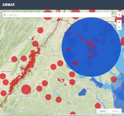
A new website AirMap has been launched and it has valuable information for anyone wanting to operate a UAV. The online map allows users to determine airspace restrictions in the area they’d like to fly an unmanned aircraft. Co-founded by entrepreneur Ben Marcus and drone legal scholar Dr. Gregory McNeal, the website allows the user to make selections, like distance from an airport, class of airspace and temporary flight restrictions.

The site culls multiple sources to provide a single picture of the allowable areas of operation in a region. The current beta version, available at airmap.io, is live in the United States, and an international version is going to launch soon. It focuses on airspace below 500 feet.

"As UAS use continues to expand, the airspace in which operators are flying is also growing more complex. With this in mind, we've launched AirMap, which will serve as a resource for drone operators to immediately fly safely and in compliance with legal requirements. We want to make safe flying easy," says Marcus.
"As a drone operator, I found it hard to know what the airspace rules were in the places where I wanted to fly,” says McNeal. “There were no accurate visuals or reliable electronic tools that could tell me and other operators where we can and cannot fly. AirMap solves this problem and helps to educate operators about this complex regulatory environment. The demand for AirMap is clear, as it is the most thorough resource for drone operators to ensure safe, legal and hassle-free flight."

(Image provided by AirMap)

FMI: www.airmap.io

Advertisement

More News

ANN's Daily Aero-Term (04.25.24): Airport Rotating Beacon

Airport Rotating Beacon A visual NAVAID operated at many airports. At civil airports, alternating white and green flashes indicate the location of the airport. At military airports>[...]

ANN's Daily Aero-Linx (04.25.24)

Aero Linx: Fly for the Culture Fly For the Culture, Inc. is a 501(c)(3) non-profit organization that serves young people interested in pursuing professions in the aviation industry>[...]

Klyde Morris (04.22.24)

Klyde Is Having Some Issues Comprehending The Fed's Priorities FMI: www.klydemorris.com>[...]

Airborne 04.24.24: INTEGRAL E, Elixir USA, M700 RVSM

Also: Viasat-uAvionix, UL94 Fuel Investigation, AF Materiel Command, NTSB Safety Alert Norges Luftsportforbund chose Aura Aero's little 2-seater in electric trim for their next gli>[...]

Airborne 04.22.24: Rotor X Worsens, Airport Fees 4 FNB?, USMC Drone Pilot

Also: EP Systems' Battery, Boeing SAF, Repeat TBM 960 Order, Japan Coast Guard H225 Buy Despite nearly 100 complaints totaling millions of dollars of potential fraud, combined with>[...]

blog comments powered by Disqus


Advertisement

Advertisement

Podcasts

Advertisement

© 2007 - 2024 Web Development & Design by Pauli Systems, LC