UAVOS And Polynesian Exploration Creating Autonomous Solution For 3D Mapping | Aero-News Network
Aero-News Network
RSS icon RSS feed
podcast icon MP3 podcast
Subscribe Aero-News e-mail Newsletter Subscribe

Airborne Unlimited -- Most Recent Daily Episodes

Episode Date

Airborne-Monday

Airborne-Tuesday

Airborne-Wednesday Airborne-Thursday

Airborne-Friday

Airborne On YouTube

Airborne-Unlimited-05.06.24

Airborne-NextGen-04.30.24

Airborne-Unlimited-05.01.24 Airborne-AffordableFlyers--05.02.24

Airborne-Unlimited-05.03.24

Thu, Nov 07, 2019

UAVOS And Polynesian Exploration Creating Autonomous Solution For 3D Mapping

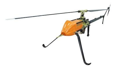
Deployed On A UVH -25EL Unmanned Helicopter

UAVOS Inc, in conjunction with the maker of the POLYSCANNER Aerial 3D Mapping and Surveying system Polynesian Navigation, Inc., has announced a partnership to provide a long-distance autonomous solution for 3D mapping.

The light unmanned helicopter UVH -25EL powered by UAVOS's autopilot is an ideal platform for a long-distance autonomous solution for 3D mapping. The UVH-25EL has increased performance with a carrying capacity, a flying range, and an extended temperature range. Take-off and landing as well as missions are carried out automatically.

The POLYSCANNER is an integrated payload solution for Aerial HD Mapping and Surveying. The system features a choice of LiDAR’s, a global shutter camera and dual frequency RTK GNSS/INS with centimeter-level accuracy, as well as a high level of integration and sensor fusion software. The system is capable of creating accurate colorized 3D models in a point cloud format.

“We have been extending into UAV service market to meet its goal of offering state-of-the-art systems that are easy to use and offer excellent cost/performance value to our customers,” said UAVOS CEO Aliaksei Stratsilatau.

(Image provided with UAVOS news release)

FMI: www.uavos.com

Advertisement

More News

ANN's Daily Aero-Term (05.09.24): Hold Procedure

Hold Procedure A predetermined maneuver which keeps aircraft within a specified airspace while awaiting further clearance from air traffic control. Also used during ground operatio>[...]

ANN's Daily Aero-Term (05.06.24): Altitude Readout

Altitude Readout An aircraft’s altitude, transmitted via the Mode C transponder feature, that is visually displayed in 100-foot increments on a radar scope having readout cap>[...]

ANN's Daily Aero-Linx (05.06.24)

Aero Linx: European Hang Gliding and Paragliding Union (EHPU) The general aim of the EHPU is to promote and protect hang gliding and paragliding in Europe. In order to achieve this>[...]

Airborne-NextGen 05.07.24: AI-Piloted F-16, AgEagle, 1st 2 WorldView Sats

Also: Skydio Chief, Uncle Sam Sues, Dash 7 magniX, OR UAS Accelerator US Secretary of the Air Force Frank Kendall was given a turn around the patch in the 'X-62A Variable In-flight>[...]

Aero-News: Quote of the Day (05.07.24)

"The need for innovation at speed and scale is greater than ever. The X-62A VISTA is a crucial platform in our efforts to develop, test and integrate AI, as well as to establish AI>[...]

blog comments powered by Disqus


Advertisement

Advertisement

Podcasts

Advertisement

© 2007 - 2024 Web Development & Design by Pauli Systems, LC