Unique Application Shown During EAA AirVenture 2016
By Maxine Scheer
The Internet of Things (IOT) has changed our lives, and this includes new and constantly evolving applications for our aviation interests. When individuals with expertise in the IOT, visualization, and big data, combine these with a passion for pilot proficiency, safety and fun, great things happen. This includes a unique and powerful flight debriefing application featured in ANN's 2016 Innovators preview, and demonstrated for attendees at AirVenture 2016 by designers from CloudAhoy, Inc.
Traditionally, a flight debrief is associated with flight training, and led by a flight instructor. But now, with the CloudAhoy App, a smartphone, and access to the web on an iPad or personal computer (PC), anyone can use and customize visual analytics, with or without a flight instructor, to improve their pilot proficiency, and presumably build more confidence and motivation.
One of CloudAhoy's founders, Tani Shavit, describes how it works. "Using a pilot's Android or Apple device, CloudAhoy software collects GPS data from a flight and integrates it with information from a comprehensive suite of aviation, weather and other resources, analyzes the flight using a rule-based knowledge engine, and displays the results with on the web or iPad device, powerful, user friendly and detail-rich, 3D, 2D, static, and animated screens," Shavit said.
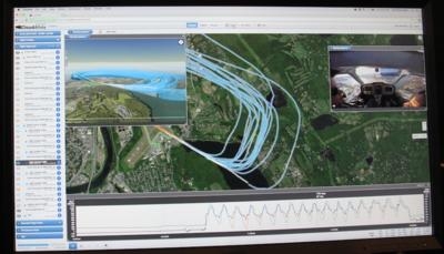
ANN was provided with a demonstration by CloudAhoy software developer Seth Richards, using an example from a recent training flight where Seth was practicing takeoffs and landings. "The software captured the GPS tracks and once in cell phone range, the data was uploaded to the CloudAhoy server," he said. The flight was also video recorded with the camera placed behind Seth and his flight instructor. "By having video, the entire flight can be relived, and syncing the video to the App is a one step process."
Richards demonstrated how he used the CloudAhoy software to sync the video, setting a visual reference (the runway threshold). He also demonstrated how he was able to choose each segment and display the performance in a variety of ways, such as comparing his rate of descent, height and width of the pattern, and visualizing each segment to an actual view of the instrument panel.
Richards also referenced a long list of data sets collected by systems such as Foreflight, Garmin, Avidyne and others, that could be integrated into CloudAhoy and provide a more comprehensive range of analytics. Looking at analysis of in-flight weather, Chuck described how he uses datasets from NOAA and FAA.
CloudAhoy founders Chuck and Tani Shavit shared their story. In 2009, shortly after fulfilling a lifelong dream of earning his private pilot certificate, Chuck began creating a "toy iPhone programming project", capturing a 3D flight track using the iPhone's internal GPS and displaying it on Google Earth. "By the time I started instrument training, the capabilities were vastly expanded and became an essential component of my training. With my foggles on, I was never sure how well I flew an instrument approach. My instructor, a man with infinite patience, kept correcting me during flight, and obviously a lot of what he said during flight was lost. I became dependent on analyzing my performance on my computer screen after every flight, and kept enhancing the program to help my debriefs."
This rest of the story is the birth of CloudAhoy. Sharing it with friends, bringing on colleagues with design and user interface expertise, and continuing to enhance features and capabilities using extensive feedback and requests from users. "Version 1.0 of the app was released to the app store in the spring of 2011," said Chuck. "The iPad came out and changed aviation forever, and in the summer of 2012 we released CloudAhoy 2.0, with in-app debrief." CloudAhoy officially started in 2010, "by the end of 2014 CloudAhoy has (become) our day job," said Chuck Shavit. "We moved to a subscription model on December 2014, and have been growing since." Both Chuck and Tani mentioned their project experience at firms such as National Semiconductor (were they met in the early 80s), Dragon systems, EMC, and Aviall. "We are problem solvers," said Tani, "we never stop until the job is done."
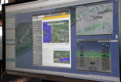
In its third year at AirVenture, CloudAhoy was also demonstrated for debriefing flights in RedBird Flight Simulators. Also announced was CloudAhoy's partnership with SkyVector. "We have customers all around the world," said Chuck Shavit. "Using the SkyVector charts significantly enhances the power of CloudAhoy debriefs for its US and international pilots."
"We are proud to partner with CloudAhoy and expect many of our users will be thrilled to see our familiar charts in their excellent debriefing application." says David Graves, SkyVector's CEO. The integrated worldwide charts are currently in beta testing by CloudAhoy users around the globe and release is expected soon after AirVenture 2016.
CloudAhoy was initially designed to analyze and help debrief maneuvers of fixed-wing flights including instrument approaches, but Tani noted helicopters and gliders pilots started to use it as well, so the App was expanded to meet their needs.
"We are in the best position any software developer can be in: we are users of our own product," said Chuck. CloudAhoy is self-funded and privately held. "The annual subscription fee is a bargain at $45."
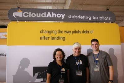
(Images provided by the author. Center photo [L-R] Tani Shavit, Chuck Shavit, Seth Richards)
 Unfortunate... ANN/SportPlane Resource Guide Adds To Cautionary Advisories

