Operation To Demonstrate Potential UAV Role In Border Patrol
Missions
U.S. Customs and Border Protection's Office of Air and Marine
has concluded surveillance operations along the U.S. side of
the maritime border of Lake Ontario and St. Lawrence Seaway, and
the land border of New York and Quebec on June 25, 2009. As part of
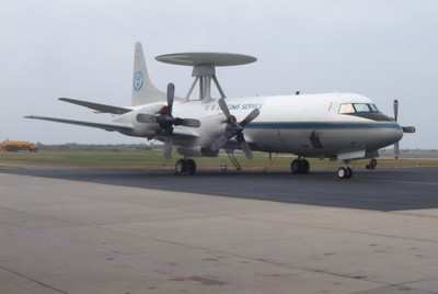
a multi-agency effort called Operation Empire Shield, CBP deployed
a Predator B unmanned aircraft system (UAS) and P-3 aircraft to the
Northern Border to perform law enforcement operations.

"The deployment was exceptional," said Michael Kostelnik, CBP
Assistant Commissioner for the Office of Air and Marine.
"Operational objectives were met, and interagency and bilateral
relationships were established and expanded.
The operation was designed to demonstrate unmanned aircraft
operations and evaluate law enforcement coordination concepts over
both land and maritime environments at the Northern Border. An
after action assessment, which will be completed in coordination
with multiple CBP offices, will be used to prepare for future UAS
expansion.
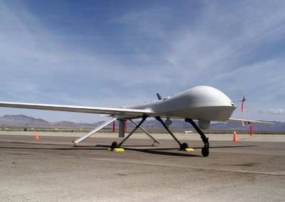
File Photo
CBP currently has six Predator B
aircraft that provide unique border security surveillance capacity
through superior optical equipment coupled with extended flight
duration. CBP's unmanned aircraft typically fly up at 250 knots at
an altitude of 19,000 feet while carrying up to 3,000 pounds of
sensors for land and maritime surveillance and tracking in day and
night environments.
Operation Empire Shield included a number of firsts for CBP's
UAS program. On Saturday, June 20, 2009, CBP demonstrated the
capability to fly and operate three UAS aircraft simultaneously in
the National Airspace System via satellite. On June 20th, UAS
from North Dakota and Arizona were launched and executed law
enforcement missions within their respective airspace. An hour
later, the third UAS was launched from Wheeler-Sack Army Airfield
in Fort Drum, New York and control of the remotely piloted aircraft
was seamlessly transferred to a crew operating from the Air and
Marine Operations Center in Riverside, California. All three
aircraft performed law enforcement missions including streaming
live video to select members of law enforcement, homeland security,
and members of the U.S. Congress.
CBP also established a milestone by completing its longest
duration UAS flight. On June 24, 2009, the UAS landed in New York
after flying over 20 hours. The ability to fly for 20 hours is
approximately twice the endurance of most manned aircraft, offering
a unique and persistent surveillance capability to secure the
homeland. During this endurance mission, control of the UAS
was passed between UAS operations centers located at New York,
North Dakota, and Arizona.
The nearly 100 hours of CBP UAS flight operations in the
Northeast are just one component of an integrated law-enforcement
effort to secure the region. The UAS deployment serves as an
exceptional opportunity for other law enforcement partners to
participate and refine concepts of operations when working with
advanced aircraft such as CBP's Predator B UAS and the P-3.
CBP Air and Marine continues to
serve as a critical component and advocate of DHS' Secure Border
Initiative. Advanced security operations such as CBP's UAS
deployment along the Northern Border is a vital element of this
strategy.
The Federal Aviation Administration remains a key facilitator
and partner of CBP Air and Marine, helping to ensure CBP UAS
flights in the Northeast integrate safely and seamlessly with other
aircraft operating in the region.
 Unfortunate... ANN/SportPlane Resource Guide Adds To Cautionary Advisories

