System Provides Dispatchers With Real-Time Info
by ANN Correspondent Maxine Scheer
 Location, Location, Location! It is
not only the mantra of real estate, but is also a critical
requirement when managing aircraft. Visitors to the Federal
Pavilion at AirVenture 2007 had the opportunity to get a real-time
demonstration of a powerful tool being used by the Department of
the Interior, Aviation Management Directorate (Aviation
Management).
Location, Location, Location! It is
not only the mantra of real estate, but is also a critical
requirement when managing aircraft. Visitors to the Federal
Pavilion at AirVenture 2007 had the opportunity to get a real-time
demonstration of a powerful tool being used by the Department of
the Interior, Aviation Management Directorate (Aviation
Management).
The tool is called Automated Flight Following (AFF), a system
that automatically tracks critical information, such as the
location, altitude, course, identifier and speed of aircraft. This
information is provided in real time to dispatchers, aviation
managers, and other system users. Aviation Management (AM) has
significantly increased efficiency, improved safety and decreased
costs as a result of its effectiveness in identifying the status of
critical situations and providing quick response by nearby
aircraft.
In any one day, the Aviation Management Division monitors and
coordinates the activities of anywhere between 500 and 1,000
aircraft, some of which are carrying out missions in remote
locations throughout the US. Examples include wildlife surveys in
the Bering Sea, fighting wildfires in the Montana or Wyoming, or
carrying inspectors to oil platforms in the Gulf of Mexico or off
the coast of California.
Before AFF, radio communications were the sole means of
establishing contact. This method has obvious limitations as
ground-based radio communications are not always reliable. Position
reports, which were sometimes required every 15 minutes, consumed
limited radio "air time," and increased dispatcher and pilot
workloads.
In 2002, DOI's Aviation Management partnered with the US Forest
Service (USFS) to develop and implement the AFF system.
Representatives at AirVenture 2007 estimate that nearly 100% of
non-military government-owned and contracted aircraft are now
equipped for the system.
Based on data published on DOI's website, a secondary
partnership was created with Canada's Province of British Columbia,
Forest Service. That government organization has tracked their
aircraft for the past ten or twelve years for purposes of search
and rescue and the tactical redeployment of firefighting
resources.
The principle value generated from this partnership has been the
sharing of a software package known as "Webtracker" (as shown in
the inset photo). This web-based system was developed by the
Canadians and has gone through modification for use by the US
Interagency Fire partners, DOI and USFS.
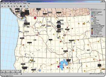
(This image of Webtracker indicates large fire locations,
temporary flight restrictions and aircraft locations. Additional
views and information can be requested by the user -- Source:
DOI Aviation Management website)
So how does the system work? A "black box" is installed in the
aircraft that "talks" with a communications satellite and receives
position information from a Global Position System (GPS) satellite.
The GPS location data is sent via the communications satellite to
an earth station and is then loaded onto the world-wide-web.
The data also includes aircraft tail number, owner, and mission
and is available to all users of the Webtracker software. Access to
the data is restricted to individuals participating in the
management of these aircraft.
Position reporting technology has been utilized by trucking
firms and the railroads for many years; however, aviation equipment
standards are much higher and many technical difficulties have been
overcome to produce the current AFF system. AFF systems are also
used in the commercial and business aviation industry by entities
such as Federal Express, UPS, and fleets used by corporate
executives.
AirVenture officials mentioned that the requirements to equip
contract aircraft for AFF were initially met with some skepticism.
However, after demonstrating the benefits of having real time data
on the position and status of people and aircraft, many of these
entities expanded the use of AFF throughout their aircraft
fleets.
Vendors who supported the program include Iridium Satellite and
its partners Latitude Technologies, Sky Connect, Blue Sky Network,
and SkyTrac Systems.
 ANN's Daily Aero-Term (04.25.24): Airport Rotating Beacon

