Earth-Observing Satellites Identify High-Risk Regions Of The Country
For the first time ever, measurements from NASA Earth-observing research satellites are being used to help combat a potential outbreak of life-threatening cholera. Humanitarian teams in Yemen are targeting areas identified by a NASA-supported project that precisely forecasts high-risk regions based on environmental conditions observed from space.
“By joining up international expertise with those working on the ground, we have for the very first time used these sophisticated predictions to help save lives and prevent needless suffering for thousands of Yemenis,” said Charlotte Watts, chief scientist with the United Kingdom’s Department for International Development.
Cholera is a disease caused by consuming food or water contaminated with a bacterium called Vibrio cholerae. The disease affects millions of people every year, resulting in severe diarrhea and even death. It remains a major threat to global health, especially in developing countries, such as Yemen, where access to clean water is limited.
Starting this spring, the British government and international aid groups in Yemen began using these new cholera forecasts to target their work in reducing cholera risk. That work includes promoting good hygiene to prevent the spread of the water-borne disease and distributing hygiene and cholera treatment kits. The results to date suggest the forecast model has the potential to fundamentally change how the international community addresses cholera.
The research on forecasting cholera outbreaks funded by NASA’s Applied Sciences Program is being led by hydrologist and civil engineer Antar Jutla at West Virginia University, Morgantown, along with Rita Colwell and Anwar Huq, microbiologists from the University of Maryland, College Park.
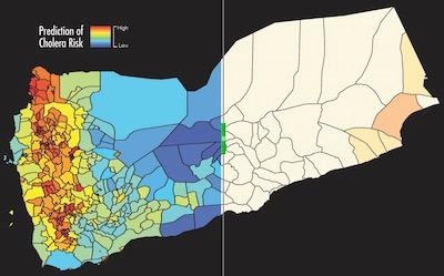
The NASA forecast tool divides the entire country of Yemen into regions about the size of a typical U.S. county, and predicts the risk of cholera outbreaks in each region. To calculate the likelihood of an outbreak, the science team runs a computer model that combines satellite observations of environmental conditions that affect the cholera bacteria with information on sanitation and clean water infrastructure.
The forecast tool analyzes a variety of NASA satellite observations, including precipitation data from the Global Precipitation Measurement mission, air and ocean temperatures from the Moderate Resolution Imaging Spectroradiometer (MODIS) instruments on NASA’s Terra and Aqua satellites, as well as measurements of phytoplankton concentrations in nearby coastal ocean areas.
In 2017, the model achieved 92 percent accuracy in predicting the regions where cholera was most likely to occur and spread in Yemen that year, even identifying inland areas that are not usually susceptible to the disease but suffered outbreaks. The Yemen cholera outbreak was the world's worst in 2017, with more than 1.1 million suspected cases and more than 2,300 deaths, according to the World Health Organization.
“The model has done an excellent job in Yemen detecting triggers of cholera outbreaks,” said Jutla, “but there is still a lot of work we need to do to have this forecast model give accurate predictions everywhere.”
International humanitarian organizations took notice. This January, Fergus McBean, a humanitarian adviser with the U.K.'s Department for International Development, read an article about the NASA-funded team's 2017 results and contacted them with an ambitious challenge: to create and implement a cholera forecasting system for Yemen, in only four months.
“It was a race against the start of rainy season,” McBean said.
The U.S. researchers began working with U.K. Aid, the U.K. Met Office, and UNICEF on the innovative approach to using the model to inform cholera risk reduction in Yemen.
In March, one month ahead of the rainy season, the U.K. international development office began using the model’s forecasts. Early results show the science team’s model predictions, coupled with Met Office weather forecasts, are helping UNICEF and other aid groups target their response to where support is needed most.
“This ground-breaking initiative is a testament to the importance of interdisciplinary and multi-agency efforts to improve disease preparedness and response,” said John Haynes, program manager for health and air quality applications in NASA’s Earth Science Division, at the agency’s headquarters in Washington.
McBean believes in this new approach. “We are confident acting on the model’s predictions this year. We know that acting early is a more effective way of operating and is likely to result in a much better outcome for people.”
Colwell, who compared the 2017 Yemen results to passing the first stage of a three-stage drug trial and discovering the drug is saving the lives of a particular type of patient, said that the science team's next step is to create global risk maps for cholera. In the same way meteorologists issue severe storms warnings, these risk maps and forecasts would allow people to prepare for and prevent outbreaks.
NASA uses the vantage point of space to understand and explore our home planet, improve lives and safeguard our future. Earth observations and information made possible by NASA form the foundation for critical environmental planning and decisions by people all over the world. The agency makes its Earth observations freely and openly available to those seeking solutions to important global issues.
(Image provided by NASA)
 ANN's Daily Aero-Term (04.24.24): Runway Lead-in Light System

