UAS Gives Scientists 3D View Of Atmosphere | Aero-News Network
Aero-News Network
RSS icon RSS feed
podcast icon MP3 podcast
Subscribe Aero-News e-mail Newsletter Subscribe

Airborne Unlimited -- Most Recent Daily Episodes

Episode Date

Airborne-Monday

Airborne-Tuesday

Airborne-Wednesday Airborne-Thursday

Airborne-Friday

Airborne On YouTube

Airborne-Unlimited-05.13.24

Airborne-NextGen-05.14.24

Airborne-Unlimited-05.15.24 Airborne-AffordableFlyers-05.16.24

Airborne-Unlimited-05.17.24

Mon, Jan 11, 2010

UAS Gives Scientists 3D View Of Atmosphere

Trio Of Aircraft Used In Climate Research

Scientists at Scripps Institution of Oceanography at UC San Diego have been using a fleet of Manta autonomous UAVs to track pollution and atmospheric data over the skies of Southern California.  The California AUAV Air Pollution Profiling Study (CAPPS) program is the latest in a series of science missions using UAS around the world.

The CAPPS began data collection on April 2, gathering a suite of meteorological data as they fly through clouds and aerosol masses in Southern California skies. When flying in formation, the aircraft can provide researchers with a unique three-dimensional view of atmospheric composition.

Miniaturized instruments on the aircraft, which typically flew in formations of three, measured a range of properties such as the quantity and size of the aerosols on which cloud droplets form. The instruments also recorded variables such as temperature, humidity and the intensity of light that permeates clouds and masses of smog. These comprehensive measurements were made at a very low cost when compared to traditional manned flights.


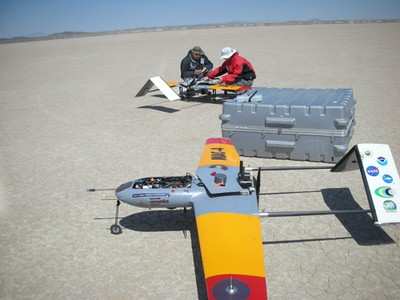
Technicians prepare the Manta for launch at Edwards AFB.

The Manta is one of several UAS produced by Advanced Ceramics Research in Tucson, AZ, now a part of BAE Systems.  Manta can carry a 15-lb payload for up to 6 hrs with a typical service altitude of 2,000-12,000 ft.  The aircraft have been deploying from NASA's Dryden Flight Research Center at Edwards AFB

Scripps researches hope to fly the system at least once a month to monitor Southern CA skies.  Future applications include real-time situational awareness during forest fires.

FMI: www.ARCTucson.com, sio.ucsd.edu

Advertisement

More News

ANN's Daily Aero-Term (05.16.24): Instrument Runway

Instrument Runway A runway equipped with electronic and visual navigation aids for which a precision or nonprecision approach procedure having straight-in landing minimums has been>[...]

ANN's Daily Aero-Linx (05.16.24)

Aero Linx: Alaska Airmen's Association The Alaska Airmen's Association includes over 2,000 members—we are one of the largest General Aviation communities in the country. We s>[...]

Airborne 05.15.24: Ghost Sq MidAir, B-2 Junked, Dream Chaser Readies

Also: Flt School Security, G600 Steep-Approach, Honduran Aid, PW545D Cert Two aircraft performing at the Fort Lauderdale Air Show clipped wings during a routine last Sunday, spooki>[...]

Airborne 05.10.24: Icon Auction, Drunk MedEvac Pilot, Bell ALFA

Also: SkyReach Parts Support, Piper Service Ctr, Airliner Near-Miss, Airshow London The Judge overseeing Icon's convoluted Chapter 11 process has approved $9 million in Chapter 11 >[...]

Airborne Affordable Flyers 05.16.24: PRA Runway, Wag-Aero Sold, Young Eagles

Also: Paramotor Champ's, Electric Ultralight, ICON BK Update, Burt Rutan at Oshkosh! The Popular Rotorcraft Association is reaching out for help in rebuilding their private runway >[...]

blog comments powered by Disqus


Advertisement

Advertisement

Podcasts

Advertisement

© 2007 - 2024 Web Development & Design by Pauli Systems, LC