Category 4 Storm Slammed The Florida Panhandle Wednesday
The 53rd Weather Reconnaissance Squadron started flying into Hurricane Michael Oct. 7 and over the next four days observed it intensify from a possible tropical depression to a Category 4 storm, which made landfall near Mexico Beach, Florida, at 12:30 p.m. Oct. 10. “This storm started out as a low level investigation with the possibility of it reaching tropical storm status by the end of the first flight,” said Col. Robert J. Stanton, 403rd Wing vice commander and navigator who was on the mission. “We had a challenge on the first entry into the storm trying to find the center because the eye of this storm was oval shaped and roughly 30 to 40 miles long.”
Stanton said that during the next two passes into the eye, they were getting better readings because the storm was developing throughout the course of their mission.
The track was predicted to hit the Florida Panhandle from the start. It was named Michael Oct. 7 and was upgraded to a Category 1 hurricane by Oct. 8. “Michael was different than others, because the track pretty much stayed the same from day one,” said Capt. Kelsie Carpenter, 53rd WRS aerial reconnaissance weather officer, who flew into the storm on Tuesday morning. “We sent the data to the National Hurricane Center and watched it go from a Category 1 to a Category 2 storm while we were fixing the center and it appeared to be intensifying.”
The 53rd WRS “Hurricane Hunters” were inside the storm as it made landfall in Florida as a Category 4.
The 53rd WRS is the only Defense Department unit that flies reconnaissance missions into severe tropical weather during the hurricane season, June 1 through Nov. 30, to gather data for the National Hurricane Center to improve their forecasts and storm warnings. In all, the squadron flew nine missions into Hurricane Michael to gather this information.
While the model forecasts have improved for tracking, Maj. Jeremy DeHart, 53rd WRS ARWO, said intensity forecasts are tricky to predict. “Data from our drop today indicated that it continued to strengthen right up to landfall,” said DeHart. “Our last dropsonde measured a central pressure of 919 millibars, which was lower than both Katrina and Andrew.”
“This was such a powerful storm for building up in the Gulf of Mexico. It doesn’t happen often that you see a storm increasing intensity while making landfall,” said Lt. Col. Sean Cross, 53rd WRS pilot.
While inside the eye, the crew could see the storm surge hitting the coastline of Florida, said Cross. “The eyewall also looked different than others I have flown because it was like we were inside an 18-mile-wide barrel or drum, with the eyewall going straight up and down,” he said.
Hurricane Michael hit the Florida Panhandle with 150 mph winds near Mexico Beach, causing massive damage. “After our experience here on the Mississippi Gulf Coast after Katrina we understand how difficult it is to experience and recover from a devastating storm,” said Stanton. “Our thoughts and prayers go out to those who are being impacted by Hurricane Michael today.”
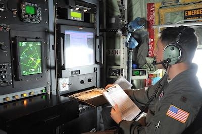
(Image provided with USAF news release. Maj. Jeremy DeHart, a 53rd Weather Reconnaissance Squadron aerial reconnaissance weather officer, reviews data prior to sending the data to the National Hurricane Center for Hurricane Michael, a Category 4 storm, which made landfall at Mexico Beach, Florida, Oct. 10, 2018)
 Airborne-Flight Training 05.09.24: ERAU at AIAA, LIFT Diamond Buy, Epic A&P

