ForeFlight’s MORA/LSALT Overlays: Better Enroute Terrain Clearance | Aero-News Network
Aero-News Network
RSS icon RSS feed
podcast icon MP3 podcast
Subscribe Aero-News e-mail Newsletter Subscribe

Airborne Unlimited -- Most Recent Daily Episodes

Episode Date

Airborne-Monday

Airborne-Tuesday

Airborne-Wednesday Airborne-Thursday

Airborne-Friday

Airborne On YouTube

Airborne-Unlimited-05.06.24

Airborne-NextGen-05.07.24

Airborne-Unlimited-05.08.24 Airborne-FlightTraining-05.09.24

Airborne-Unlimited-05.10.24

Tue, Mar 26, 2024

ForeFlight’s MORA/LSALT Overlays: Better Enroute Terrain Clearance

Grid Overlay Is A Feature That Promises To Improve Enroute Terrain Clearance For Pilots

The aviation industry continually seeks advancements in technology to enhance flight safety and pilot confidence. 

One of the latest innovations in this field is the introduction of ForeFlight’s MORA/LSALT MORA, or Minimum Off-Route Altitude, and LSALT, the Lowest Safe Altitude in Australia, are essential metrics for pilots to maintain safe clearance from terrain and obstacles when deviating from a planned route. 

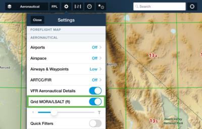
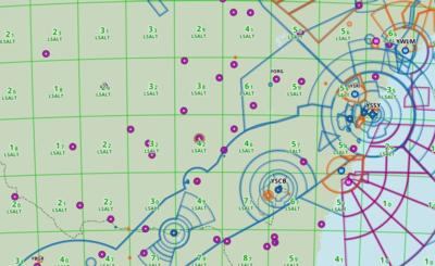
ForeFlight's new overlay feature integrates these altitudes directly onto the Aeronautical Map, providing a visual aid that is invaluable for flight planning and in-flight navigation. The overlay displays altitudes in feet, with the first number indicating thousands and the second, smaller number indicating hundreds within the grid. This design allows pilots to quickly ascertain the minimum safe altitudes required for their flight path. 

As pilots zoom in on the map, the grid dynamically adjusts from a 5°x5° to a 1°x1° scale, offering more granular information.

A key aspect of the Grid MORA overlay is its color-coding system. Altitudes below 10,000 feet are shown in green, signaling lower terrain or obstacle heights, while altitudes above 10,000 feet are marked in red, denoting higher terrain or obstacles. This immediate visual distinction aids pilots in making quick, informed decisions about their altitude, especially in unfamiliar or challenging environments.

The Grid MORA also includes altitude buffers of 1,000 feet for altitudes of 6,000 feet or less and a 2,000 feet buffer for altitudes above 7,000 feet. These buffers provide a global standard for obstacle clearance, differing from the U.S.-specific OROCA, which uses a uniform 1,000-foot buffer except in designated mountainous regions where it increases to 2,000 feet.

ForeFlight’s dedication to pilot safety is further demonstrated by additional features such as Aircraft on Same Runway Alerts and Controlled Airspace Alerts, which now include RMZs (Radio Mandatory Zones) and their frequencies. These alerts offer critical safety information and convenient reference points for pilots navigating controlled airspace.

The MORA/LSALT Grid Overlay is enabled by default but can be turned off in the Map Settings for those who prefer a traditional view. This flexibility ensures that ForeFlight?s application meets the diverse needs of the aviation community. 

By providing pilots with an intuitive, visual representation of safe altitudes, ForeFlight enhances pilot confidence and contributes to safer skies. Tools like the MORA/LSALT Grid Overlay will undoubtedly become indispensable in a pilot’s tool set.

FMI: www.foreflight.com

Advertisement

More News

Airborne-Flight Training 05.09.24: ERAU at AIAA, LIFT Diamond Buy, Epic A&P

Also: Vertical Flight Society, NBAA Maintenance Conference, GA Honored, AMT Scholarship For the first time, students from Embry-Riddle’s Daytona Beach, Florida, campus took t>[...]

ANN's Daily Aero-Term (05.07.24): Hazardous Weather Information

Hazardous Weather Information Summary of significant meteorological information (SIGMET/WS), convective significant meteorological information (convective SIGMET/WST), urgent pilot>[...]

Aero-News: Quote of the Day (05.07.24)

"The need for innovation at speed and scale is greater than ever. The X-62A VISTA is a crucial platform in our efforts to develop, test and integrate AI, as well as to establish AI>[...]

NTSB Final Report: Cessna 150

(FAA) Inspector Observed That Both Fuel Tanks Were Intact And That Only A Minimal Amount Of Fuel Remained In Each Analysis: According to the pilot, approximately 8 miles from the d>[...]

Aero-News: Quote of the Day (05.08.24)

“Pyka’s Pelican Cargo is unlike any other UAS solution on the market for contested logistics. We assessed a number of leading capabilities and concluded that the Pelica>[...]

blog comments powered by Disqus


Advertisement

Advertisement

Podcasts

Advertisement

© 2007 - 2024 Web Development & Design by Pauli Systems, LC