Will Enable The Digital Transformation Of Aggregate Operations
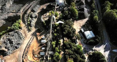
Delair, a provider of enterprise visual data management solutions, has signed an agreement in France with CEMEX, a supplier to the construction industry. As part of this three-year agreement, CEMEX will deploy delair.ai, a new cloud platform for analyzing and leveraging data collected by drones, satellites and other aerial methods, for their 60 aggregate production sites in France. With delair.ai, CEMEX will get access to highly accurate, 3D topographic surveys along with advanced analytics to calculate volumes of materials, resulting in a better forecast of production, improved operations and reduced operational costs.
“Production monitoring, inventory management, and the safety of our teams are the three key performance indicators of our production sites. Delair’s comprehensive platform for visual data collection and management will help us accelerate the digitalization of our activities, significantly improving all aspects of our operational efficiency,” said Benjamin Lecendrier, director of Production and Joint-Ventures at CEMEX France Nord.
"Delair’s comprehensive platform for visual data collection and management will help us accelerate the digitalization of our activities, significantly improving all aspects of our operational efficiency," said Benjamin Lecendrier, director of Production and Joint-Ventures at CEMEX France Nord.
Delair.ai will provide CEMEX with a completely integrated and easy-to-use workflow to manage, analyze and share data, streamlining the process for unlocking the true potential of aerial surveying. Intuitive features on the platform allow users to visualize a site in 2D or 3D. delair.ai has the capacity as well to provide orthophotography, slope maps, digital surface models and 3D models.
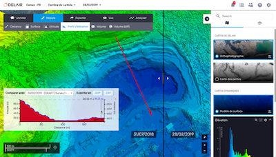
Making measurements are quick and simple, with integrated tools for calculating length, determining an area size, and calculating stockpile volumes. More frequent updates of topographic data will allow the company to better forecast its production and increase revenue, with more insight into planning of extraction and extension projects, measuring of stockpiles, managing entire site inventories, and optimizing haul roads. This will contribute to standardize best practices and processes enterprise-wide.
Delair.ai’s cloud-based approach simplifies data storage and access, making it ideal for the CEMEX team to collaborate and archive data. The platform is inherently scalable, supporting the use of multiple UAVs and data collection techniques. An unlimited number of projects can be stored and shared, providing access to critical data by anyone who needs it across the enterprise: surveyors, production department or financial services.
“Being able to share data seamlessly between the different departments of the company and our production sites, and with subcontractors, has been a determining factor in choosing Delair’s solution. Our teams can collaborate from a single interface online, anywhere, anytime. The delair.ai platform is scaled to meet our evolving needs and can be easily deployed nationwide,” noted Lecendrier.
(Images provided with Delair news release)
 ANN's Daily Aero-Term (05.09.24): Hold Procedure

