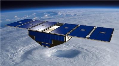
All Eight Satellites Are 'In Good Shape'
NASA confirmed Friday morning that all eight spacecraft of its latest Earth science mission are in good shape. The Cyclone Global Navigation Satellite System (CYGNSS) will provide scientists with advanced technology to see inside tropical storms and hurricanes like never before.
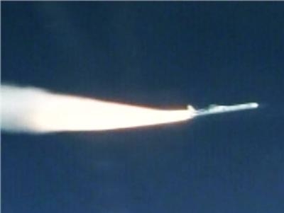
CYGNSS launched into orbit at 8:37 a.m. EST Thursday aboard an Orbital ATK air-launched Pegasus XL launch vehicle. The rocket was dropped and launched from Orbital’s Stargazer L-1011 aircraft, which took off from Cape Canaveral Air Force Station in Florida, over the Atlantic Ocean, off the coast of central Florida.
“The launch of CYGNSS is a first for NASA and for the scientific community,” said Thomas Zurbuchen, associate administrator for the agency’s Science Mission Directorate in Washington. “As the first orbital mission in our Earth Venture program, CYGNSS will make unprecedented measurements in the most violent, dynamic, and important portions of tropical storms and hurricanes.”
The CYGNSS constellation will make frequent and accurate measurements of ocean surface winds in and near a hurricane’s inner core, including regions beneath the eyewall and intense inner rainbands that previously could not be measured from space. CYGNSS will do this by using both direct and reflected signals from existing GPS satellites to obtain estimates of surface wind speed over the ocean.
“CYGNSS will provide us with detailed measurements of hurricane wind speeds, an important indicator of a storm’s intensity,” said Christopher Ruf, CYGNSS principal investigator at the University of Michigan’s Department of Climate and Space Sciences and Engineering in Ann Arbor. “Ultimately, the measurements from this mission will help improve hurricane track and intensity forecasts.”
CYGNSS is the first orbital mission competitively selected by NASA’s Earth Venture program, managed by the Earth System Science Pathfinder (ESSP) Program Office at NASA’s Langley Research Center, Hampton, Virginia. This program focuses on low-cost, science-driven missions to enhance our understanding of the current state of Earth and its complex, dynamic system and enable continual improvement in the prediction of future changes.
“There is a feeling of pride and joy knowing that you have been a part of something that is much bigger than yourself and will potentially have a significant positive impact on the general public safety,” said Jim Wells, ESSP mission manager.
Southwest Research Institute in San Antonio led the development, integration and operation of the CYGNSS microsatellites. The Space Physics Research Laboratory at the University of Michigan College of Engineering leads the overall mission execution, and its Climate and Space Sciences and Engineering department leads the science investigation. The Earth Science Division of NASA’s Science Mission Directorate oversees the mission.
The NASA Launch Services Program, based at the agency’s Kennedy Space Center in Florida, was responsible for spacecraft/launch vehicle integration and launch management. Orbital ATK Corp. of Dulles, Virginia, provided the Pegasus XL launch service to NASA.
(Images from file and provided with NASA news release)
 ANN's Daily Aero-Linx (05.02.24)

