Thu, Mar 08, 2012
ICAO-Compliant Digital Terrain And Obstacle Data Now Available Worldwide
An agreement between GE Aviation and GeoEye will make ICAO-compliant terrain and obstacle aeronautical data derived from GeoEye’s high resolution Earth imagery available to the aviation industry. GE is showcasing this technology at ATC Global this week in Amsterdam.
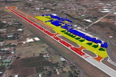
As the first offering under this agreement, GE will provide ICAO Annex 15 Area-2 terrain and obstacle databases to support the development of new Performance-based Navigation (PBN) flight paths around the world. This digital, highly detailed terrain and obstacle mapping, collected by some of the world’s highest-resolution commercial earth-imaging satellites, will support the world's airport, airlines and aviation authorities as they move to adopt PBN.
“This advanced aeronautical data, along with our Required Navigation Performance (RNP) products, will accelerate the deployment of RNP flight paths that will help meet the global challenge of increasing efficiency in the world's air traffic management system,” said Giovanni Spitale, general manager of GE’s PBN Services. “It will allow the benefits of PBN to be achieved earlier for the global air transportation community - saving time, fuel, reducing emissions and noise while increasing hourly operations frequency and maintaining safety.”
Additional GE Aviation offerings under the agreement will support advanced terrain and obstacle visualization, surface guidance through airport mapping databases (AMDB), pilot simulator training and flight operations quality assurance (FOQA) replay. Avionics providers, airlines, and ANSPs will benefit from access to accurate and current real world views of critical topography, obstacles and airport details.
“Over the next decade, we will eventually provide this aeronautical data for hundreds of airports in the world,” continued Spitale. “This will become the reference geospatial database for the aviation community.” (Image provided by GE Avaition)
More News
Airport Marking Aids Markings used on runway and taxiway surfaces to identify a specific runway, a runway threshold, a centerline, a hold line, etc. A runway should be marked in ac>[...]
"It is extremely difficult, if not impossible, for manned aircraft to see a drone while conducting crop-enhancing and other aerial applications at low altitudes and high speeds. We>[...]
Aero Linx: The Skyhawk Association The Skyhawk Association is a non-profit organization founded by former Skyhawk Pilots which is open to anyone with an affinity for the A-4 Skyhaw>[...]
“The T-54A benefits from an active Beechcraft King Air assembly line in Wichita, Kansas, where all required METS avionics and interior modifications are installed on the line>[...]
Aero Linx: Aerostar Owners Association The Association offers the Aerostar Owner a unique opportunity to tap an invaluable source of information concerning the care and feeding of >[...]
 ANN's Daily Aero-Term (04.28.24): Airport Marking Aids

