USGS To Conduct Aerial Fault Mapping In Oklahoma | Aero-News Network
Aero-News Network
RSS icon RSS feed
podcast icon MP3 podcast
Subscribe Aero-News e-mail Newsletter Subscribe

Airborne Unlimited -- Most Recent Daily Episodes

Episode Date

Airborne-Monday

Airborne-Tuesday

Airborne-Wednesday Airborne-Thursday

Airborne-Friday

Airborne On YouTube

Airborne-Unlimited-04.29.24

Airborne-NextGen-04.30.24

Airborne-Unlimited-05.01.24 Airborne-AffordableFlyers--05.02.24

Airborne-Unlimited-05.03.24

Fri, Aug 18, 2017

USGS To Conduct Aerial Fault Mapping In Oklahoma

Surveys Will Take Six To 10 Weeks To Complete

Scientists with the U.S. Geological Survey and Oklahoma Geological Survey are teaming up to better understand the location of deep faults and subsurface geology via airborne technology.

USGS and OGS are contracting Goldak Airborne Surveys to conduct surveys that will fly over 18 counties in the southwestern and north-central part of the state. The goal is to capture 3-D images of geology beneath the Earth’s surface for earthquake hazard and mineral resources.

Weather permitting, the surveys will take approximately 6-10 weeks to complete. Operations will be based out of Altus, Oklahoma.

“Oklahoma has been experiencing increased seismicity since about 2009. Many of these earthquakes occur on faults that haven’t been mapped,” said USGS scientist and project lead Dr. Anji Shah. “In order to better understand local seismic hazards, the USGS and OGS will use the new data to work towards improved fault maps.”

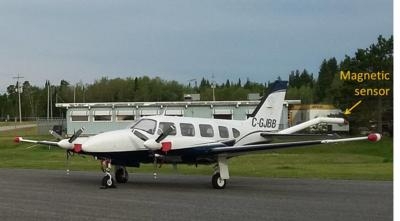
Instruments on the airplane will measure variations in the Earth’s magnetic field created by different rock types up to several miles beneath the surface. The magnetic field maps will help with imaging faults as well as intrusions, which are rocks formed by ancient volcanic eruptions that never reached the surface. The scientific instruments on the airplane are completely passive, with no emissions that pose a risk to humans, animals, or plant life.

Survey areas will include parts of Alfalfa, Beckham, Comanche, Greer, Harmon, Kiowa, Jackson, Lincoln, Logan, Major, Noble, Pawnee, Payne, Pottawatomie, Stephens, Tillman, Woods and Woodward counties.

(Image provided with USGS news release)

FMI: www.usgs.gov

Advertisement

More News

ANN's Daily Aero-Term (05.01.24): Say Altitude

Say Altitude Used by ATC to ascertain an aircraft's specific altitude/flight level. When the aircraft is climbing or descending, the pilot should state the indicated altitude round>[...]

ANN's Daily Aero-Linx (05.01.24)

Aero Linx: European Air Law Association (EALA) EALA was established in 1988 with the aim to promote the study of European air law and to provide an open forum for those with an int>[...]

Classic Aero-TV: Korean War Hero Twice Reborn

From 2023 (YouTube Version): The Life, Death, Life, Death, and Life of a Glorious Warbird In 1981, business-owner Jim Tobul and his father purchased a Chance-Vought F4U Corsair. Mo>[...]

Airborne 04.29.24: EAA B-25 Rides, Textron 2024, G700 Deliveries

Also: USCG Retires MH-65 Dolphins, Irish Aviation Authority, NATCA Warns FAA, Diamond DA42 AD This summer, history enthusiasts will have a unique opportunity to experience World Wa>[...]

Airborne Affordable Flyers 05.02.24: Bobby Bailey, SPRG Report Cards, Skydive!

Also: WACO Kitchen Bails, French SportPlane Mfr to FL, Dynon-Advance Flight Systems, Innovation Preview Bobby Bailey, a bit of a fixture in sport aviation circles for his work with>[...]

blog comments powered by Disqus


Advertisement

Advertisement

Podcasts

Advertisement

© 2007 - 2024 Web Development & Design by Pauli Systems, LC