GPS Testing Continuing In Western U.S. | Aero-News Network
Aero-News Network
RSS icon RSS feed
podcast icon MP3 podcast
Subscribe Aero-News e-mail Newsletter Subscribe

Airborne Unlimited -- Most Recent Daily Episodes

Episode Date

Airborne-Monday

Airborne-Tuesday

Airborne-Wednesday Airborne-Thursday

Airborne-Friday

Airborne On YouTube

Airborne-Unlimited-04.29.24

Airborne-Unlimited-04.23.24

Airborne-Unlimited-04.24.24 Airborne-FltTraining-04.25.24

Airborne-Unlimited-04.26.24

Tue, Nov 23, 2010

GPS Testing Continuing In Western U.S.

Unavailable Or Unreliable Signals Possible Through December 9

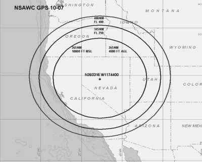
The FAA is continuing its GPS testing in an area that may affect the reliability of GPS signals in several western states from California to Idaho, western Colorado and Wyoming.  The testing is Centered at 393316N/1174400W or the BAM VOR 211.7 degree radial at 71.4NM.

GPS testing scheduled from November 22nd through December 9th, 2010 as following:
22 NOV 2100Z – 23 NOV 0445Z
23 NOV 1700Z – 24 NOV 0030Z
29 NOV 2100Z – 30 NOV 0445Z
30 NOV 1600Z – 30 NOV 2359Z
01 DEC 2301Z – 02 DEC 0445Z
02 DEC 1600Z – 02 DEC 2359Z
03 DEC 0130Z – 03 DEC 0330Z
03 DEC 1300Z – 03 DEC 2100Z
07 DEC 1300Z – 07 DEC 2359Z
08 DEC 1200Z – 09 DEC 0530Z

Pilots are advised to check NOTAMs frequently for possible changes prior to operating in the area. Times listed are GMT. The test will be conducted in continuous blocks throughout the period outlined, and the FAA says the GPS signal may be unreliable or unavailable within an area centered at
393316N/1174400W or the BAM VOR 211.7 degree radial at 71.4NM out to a distance of 400NM at FL400, decreasing in area with a decrease in altitude to an area with a radius of 345NM at FL250, an area with a radius of 265NM at 10,000FT MSL and an area with a radius of 265NM at 4,000FT AGL.

The agency asks that any aircraft unable to navigate due to loss of GPS is requested to advise ATC for additional assistance. Pilots should report anomalies during testing to the appropriate ATC Facility to assist in the determination of the extent of GPS degradation during tests. When making such a report, pilots are asked to include their aircraft call sign and type, as well as location, altitude, date and time of occurrence and remarks, such as how testing impacted aircraft navigation.

The NOTAM indicates that the impacted ARTCCs are ZSE, ZLC, ZDV, ZOA, ZIA and ZAB. The NOTAMs discussed in this advisory may change with little or no notice. Pilots are advised to check NOTAMs frequently for possible changes prior to operations in the area. The FAA says NOTAMs will be published at least 72 hours in advance of any GPS tests.

FMI: www.faa.gov

Advertisement

More News

Unfortunate... ANN/SportPlane Resource Guide Adds To Cautionary Advisories

The Industry Continues to be Rocked By Some Questionable Operations Recent investigations and a great deal of data has resulted in ANN’s SportPlane Resource Guide’s rep>[...]

ANN FAQ: Turn On Post Notifications

Make Sure You NEVER Miss A New Story From Aero-News Network Do you ever feel like you never see posts from a certain person or page on Facebook or Instagram? Here’s how you c>[...]

ANN's Daily Aero-Term (04.29.24): Visual Approach Slope Indicator (VASI)

Visual Approach Slope Indicator (VASI) An airport lighting facility providing vertical visual approach slope guidance to aircraft during approach to landing by radiating a directio>[...]

ANN's Daily Aero-Term (04.28.24): Airport Marking Aids

Airport Marking Aids Markings used on runway and taxiway surfaces to identify a specific runway, a runway threshold, a centerline, a hold line, etc. A runway should be marked in ac>[...]

ANN's Daily Aero-Linx (04.28.24)

Aero Linx: The Skyhawk Association The Skyhawk Association is a non-profit organization founded by former Skyhawk Pilots which is open to anyone with an affinity for the A-4 Skyhaw>[...]

blog comments powered by Disqus


Advertisement

Advertisement

Podcasts

Advertisement

© 2007 - 2024 Web Development & Design by Pauli Systems, LC