Robinson Intro's Moving Map for R44 Police Helo | Aero-News Network
Aero-News Network
RSS icon RSS feed
podcast icon MP3 podcast
Subscribe Aero-News e-mail Newsletter Subscribe

Airborne Unlimited -- Most Recent Daily Episodes

Episode Date

Airborne-Monday

Airborne-Tuesday

Airborne-Wednesday Airborne-Thursday

Airborne-Friday

Airborne On YouTube

Airborne-Unlimited-04.29.24

Airborne-NextGen-04.30.24

Airborne-Unlimited-05.01.24 Airborne-AffordableFlyers--05.02.24

Airborne-Unlimited-05.03.24

Mon, Oct 24, 2005

Robinson Intro's Moving Map for R44 Police Helo

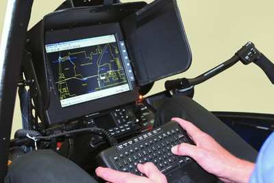
A new GPS moving map system is now available for the R44 Raven II Police Helicopter. To create the system Robinson combined software designed by Greg Taylor of Flight Management Systems with existing R44 hardware. With this combination the operator can type in a particular address, which is then displayed on a street map showing the location of the address along with the position of the helicopter.

Direction, distance, and estimated time of arrival are also displayed, providing the police with an easy-to-use map to guide them to their destination.

The FAA-approved installation includes a Stealth personal computer with Intel 1.2 GHz Celeron processor, custom keyboard and moving map software. The image is displayed on the same 10-inch Transvideo fold-down monitor currently used with the FLIR infrared camera system.

Buttons on the screen allow the observer to switch between the FLIR images and map display. GPS helicopter position data is provided by the Garmin 420 GPS/Com, standard equipment on the Police Helicopter.

The onboard computer system also accommodates a mobile data terminal “MDT” system which allows two-way communication with the dispatch computers at the police station and in squad cars. The observer can obtain unit status, vehicle descriptions, active call information, and respond to calls directly through the computer. Call addresses posted on the dispatch screen can be pasted directly into the moving map address window, eliminating keystrokes and reducing response time.

List price for the moving map option is US $15,000 which includes installation of parcel map data (supplied by police agency where available). Weight of the added optional equipment is approximately 10 lbs. After six months of testing the system in his R44 Police Helicopter, Leo Bell of CA Aviation Services feels that “with the moving map and MDT system, the R44 is now one of the best equipped police helicopters available.”

FMI: www.robinsonheli.com

Advertisement

More News

ANN's Daily Aero-Term (05.02.24): Touchdown Zone Lighting

Touchdown Zone Lighting Two rows of transverse light bars located symmetrically about the runway centerline normally at 100 foot intervals. The basic system extends 3,000 feet alon>[...]

Aero-News: Quote of the Day (05.02.24)

“Discovery and innovation are central to our mission at Virgin Galactic. We’re excited to build on our successful record of facilitating scientific experiments in subor>[...]

Aero-News: Quote of the Day (05.03.24)

"We are reaching out to you today on behalf of the Popular Rotorcraft Association because we need your help. We are dangerously close to losing a critical resource that if lost, wi>[...]

ANN's Daily Aero-Term (05.03.24): UAS Traffic Management (UTM)

UAS Traffic Management (UTM) The unmanned aircraft traffic management ecosystem that will allow multiple low altitude BVLOS operations and which is separate from, but complementary>[...]

ANN's Daily Aero-Linx (05.03.24)

Aero Linx: Society of Aviation and Flight Educators (SAFE) SAFE is a member-oriented organization of aviation educators fostering professionalism and excellence in aviation through>[...]

blog comments powered by Disqus


Advertisement

Advertisement

Podcasts

Advertisement

© 2007 - 2024 Web Development & Design by Pauli Systems, LC