Google Extends Its Reach Into The Cosmos | Aero-News Network
Aero-News Network
RSS icon RSS feed
podcast icon MP3 podcast
Subscribe Aero-News e-mail Newsletter Subscribe

Airborne Unlimited -- Most Recent Daily Episodes

Episode Date

Airborne-Monday

Airborne-Tuesday

Airborne-Wednesday Airborne-Thursday

Airborne-Friday

Airborne On YouTube

Airborne-Unlimited-04.01.24

Airborne-Unlimited-04.09.24

Airborne-Unlimited-04.10.24 Airborne-Unlimited-04.11.24

Airborne-Unlimited-04.12.24

Join Us At 0900ET, Friday, 4/10, for the LIVE Morning Brief.
Watch It LIVE at
www.airborne-live.net

Thu, Aug 23, 2007

Google Extends Its Reach Into The Cosmos

Unveils "Sky In Google Earth"... ET Better Watch Out...

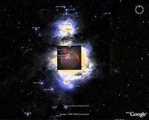
Imagine cruising the heavens from your desktop and seeing all the spectacular images from the NASA/ESA Hubble Space Telescope. Exploding stars and faraway galaxies are just a mouse click away today through 'Sky in Google Earth.'

'Sky in Google Earth' is produced by Google, and can be downloaded free of charge with the newest version of Google Earth. Several elements of Sky in Google Earth have been contributed by the European Space Agency.

With Sky in Google Earth, you can travel across the vastness of the night sky, making tour stops at 125 of the most popular Hubble images. Though these celestial objects are far away from Earth, you can reach them in a few seconds with Sky in Google Earth.

Travellers can begin their celestial tour by selecting 'Switch to Sky' from the 'view' drop-down menu in Google Earth. From here, an object, such as the Eagle Nebula - the so-called pillars of creation - or even a category, such as colliding galaxies, can be selected from a menu. You will first get a view of the sky showing the constellations surrounding your selected object. As you zoom in, the constellations disappear and your chosen object emerges from the background.

The Hubble images are set within a background of real stars and galaxies taken by two powerful visible-light surveys of the heavens, the Digitized Sky Survey and the Sloan Digital Sky Survey. The Digitized Sky Survey comprises photographic surveys of nearly the entire sky and contains about a million objects. The Sloan survey comprises images of hundreds of millions of much fainter objects and covers more than a quarter of the sky.

"The Hubble Space Telescope is a project of international cooperation between ESA and NASA and we are now happy to see that, thanks to Hubble's wonderful images, Sky in Google Earth is like having the heavens at your fingertips. ESA has already had a partnership with Google Earth for the provision of spectacular Earth images since 2006." said Fernando Doblas, Head of ESA Communication.

Pretty pictures are not the only part of this versatile program. By clicking on the icon of the HubbleSite logo, information on the object taken from the press release or photo caption will appear. Sky in Google Earth also will provide links to the Hubble news database and other Hubble information.

Newly released Hubble pictures will be added to the Sky in Google Earth program as soon as they are issued. Sky in Google Earth is produced by Google, through a partnership with Space Telescope Science Institute, Hubble's home institute.

Given the furor surrounding revelations of Google Earth's amazing accuracy and detail -- sometimes extending to being able to see actual faces of people on the street, some of whom would prefer you not be able to do that -- does anyone else think this may just represent our best chance yet to find alien life?

FMI: www.earth.google.com, www.esa.int

Advertisement

More News

ANN's Daily Aero-Linx (04.13.24)

Aero Linx: Florida Antique Biplane Association "Biplanes.....outrageous fun since 1903." That quote really defines what the Florida Antique Biplane Association (FABA) is all about.>[...]

ANN's Daily Aero-Term (04.13.24): Beyond Visual Line Of Sight (BVLOS)

Beyond Visual Line Of Sight (BVLOS) The operation of a UAS beyond the visual capability of the flight crew members (i.e., remote pilot in command [RPIC], the person manipulating th>[...]

Airborne 04.09.24: SnF24!, Piper-DeltaHawk!, Fisher Update, Junkers

Also: ForeFlight Upgrades, Cicare USA, Vittorazi Engines, EarthX We have a number of late-breaking news highlights from the 2024 Innovation Preview... which was PACKED with real ne>[...]

Aero-News: Quote of the Day (04.14.24)

“For Montaer Aircraft it is a very prudent move to incorporate such reliable institution as Ocala Aviation, with the background of decades in training experience and aviation>[...]

ANN's Daily Aero-Term (04.14.24): Maximum Authorized Altitude

Maximum Authorized Altitude A published altitude representing the maximum usable altitude or flight level for an airspace structure or route segment. It is the highest altitude on >[...]

blog comments powered by Disqus


Advertisement

Advertisement

Podcasts

Advertisement

© 2007 - 2024 Web Development & Design by Pauli Systems, LC