Crash Got Intensive Media Attention Due To Number of People,
Kids On Board
 The wife of a pilot who
died in a tragic accident on March 22nd, has reportedly been
cleared of any influence from drugs or alcohol -- according to a
report that she claims to have seen, but has yet to be released to
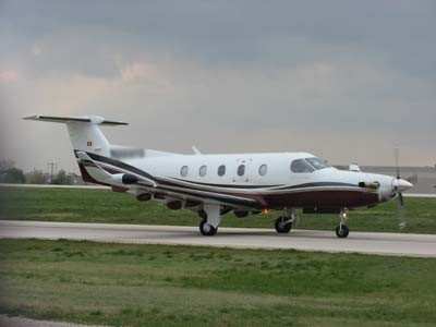
the public. The Butte, MT, killed 14 people, while on the way to a
ski vacation, in a single-engine turboprop PC-12 being flown by
Ellison "Buddy" Summerfield (65).
The wife of a pilot who
died in a tragic accident on March 22nd, has reportedly been
cleared of any influence from drugs or alcohol -- according to a
report that she claims to have seen, but has yet to be released to
the public. The Butte, MT, killed 14 people, while on the way to a
ski vacation, in a single-engine turboprop PC-12 being flown by
Ellison "Buddy" Summerfield (65).
Statements made by Janet Summerfield indicate that the report,
prepared by the Butte-Silver Bow coroner, indicate the a copy of
the report has been made available to her and that the results 'do
not show that her husband had drugs in his system or that he
suffered from a medical condition before the wreck.'
Summerfield added that her husband, "habitually piloted his
aircraft with an exceptional degree of skill, competence and
responsibility." The Summerfield's lawyer also claimed that the
pilot did not have a heart attack and that his liver was clear of
any medications.
The NTSB prelim stated that, "on March 22, 2009, at 1430
mountain daylight time, a Pilatus PC-12/45, N128CM, descended to
ground impact near the approach end of runway 33 at the Bert Mooney
Airport, Butte, Montana. The airplane was owned and operated by
Eagle Capital Leasing, of Enterprise, Oregon, as a personal
transportation flight under the provisions of 14 Code of Federal
Regulations Part 91. The airplane was destroyed in the collision
sequence and post crash fire. All 14 persons onboard the airplane
were killed in the accident and there were no reported ground
injuries. The flight departed Oroville, California, at 1210 Pacific
daylight time on an instrument flight rules (IFR) flight plan and
clearance destined for Gallatin Field, Bozeman, Montana. The
airplane was diverting to Butte at the time of the accident. Visual
meteorological conditions prevailed at both the Bozeman and Butte
airports."
The airplane impacted the Holy Cross cemetery west of runway 33
at Bert Mooney Airport, Butte, Montana. The wreckage was confined
to the impact area and consumed by impact and fire. Portions of all
major structural components were identified.
Interviews with family members indicated that seven adults and
seven children were traveling to Bozeman, Montana, to meet other
family members and friends for a ski vacation. The owner of the
airplane drove from California with his wife and other family
members. The airplane originally departed Redlands, California,
flew to Nut Tree Airport, Vacaville, California, where passengers
were picked up. The pilot then flew to Oroville, California, where
additional passengers were picked up.
 According to a preliminary briefing from the FAA regarding air
traffic control, the pilot filed an instrument flight rules flight
plan from Oroville, California (KOVE) to Bozeman, Montana (KBZN)
with Butte, Montana (KBTM) as the alternate. The airplane departed
at 1210 local. At 1359 the crew contacted the Salt Lake City
Center. At 1403, the airplane was at FL 250 and the pilot requested
to change his destination to Butte and gave no reason for the
diversion. He was cleared at pilot's discretion to descend to
14,000 feet, and at 1405 the pilot again requested to divert to
Butte. At 1427 air traffic control asked the pilot if he had the
airport in sight and the pilot indicated he had one more cloud to
maneuver around. At 1428 the pilot reported the airport in sight
and air traffic control terminated radar service. At 1429, air
traffic control called the aircraft in the blind with no response.
The accident was reported to local authorities at 1433.
According to a preliminary briefing from the FAA regarding air
traffic control, the pilot filed an instrument flight rules flight
plan from Oroville, California (KOVE) to Bozeman, Montana (KBZN)
with Butte, Montana (KBTM) as the alternate. The airplane departed
at 1210 local. At 1359 the crew contacted the Salt Lake City
Center. At 1403, the airplane was at FL 250 and the pilot requested
to change his destination to Butte and gave no reason for the
diversion. He was cleared at pilot's discretion to descend to
14,000 feet, and at 1405 the pilot again requested to divert to
Butte. At 1427 air traffic control asked the pilot if he had the
airport in sight and the pilot indicated he had one more cloud to
maneuver around. At 1428 the pilot reported the airport in sight
and air traffic control terminated radar service. At 1429, air
traffic control called the aircraft in the blind with no response.
The accident was reported to local authorities at 1433.
Initial reports from ground witnesses indicate that the airplane
was flying approximately 300 feet above ground level in a
north-northwesterly direction. Shortly thereafter, the airplane's
nose pitched to a nose-low attitude and it impacted the ground. One
witness with aviation experience reported that the airplane was
west of the runway centerline and appeared too high to land on the
runway. The witness then saw the airplane bank to the left and fly
farther west when it rolled, pitched down, and descended out of his
view. Although there is no air traffic control tower at Butte, the
local fixed base operator lineman was monitoring the radio as the
airplane approached the airport. He heard the pilot transmit that
he would be landing on runway 33.
 ANN's Daily Aero-Linx (04.15.24)

