City Not Worried About Possible Bridge Hazard Near MKC | Aero-News Network
Aero-News Network
RSS icon RSS feed
podcast icon MP3 podcast
Subscribe Aero-News e-mail Newsletter Subscribe

Airborne Unlimited -- Most Recent Daily Episodes

Episode Date

Airborne-Monday

Airborne-Tuesday

Airborne-Wednesday Airborne-Thursday

Airborne-Friday

Airborne On YouTube

Airborne-Unlimited-04.01.24

Airborne-Unlimited-04.16.24

Airborne-FlightTraining-04.17.24 Airborne-Unlimited-04.11.24

Airborne-Unlimited-04.12.24

Join Us At 0900ET, Friday, 4/10, for the LIVE Morning Brief.
Watch It LIVE at
www.airborne-live.net

Mon, Dec 17, 2007

City Not Worried About Possible Bridge Hazard Near MKC

But FAA May Impose New Restrictions

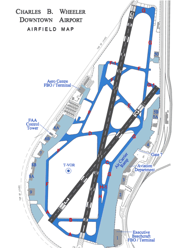
The Federal Aviation Administration has warned officials in Kansas City, MO that the design for the new Paseo Bridge poses a hazard for aircraft at Charles B. Wheeler Downtown Airport (MKC), according to the Kansas City Star.

The FAA issued a notice December 4, stating the height of a tower on the proposed bridge -- 220 feet AGL -- would interfere with navigable air space around the airport.

"If this is built, as it was explained to us, there could be some hazard to planes flying into that airport," said FAA spokesman Tony Molinaro, adding the agency can't
stop the Missouri Department of Transportation from the allowing the tower in the design.

If the bridge is constructed as proposed, however, it could result in new flight restrictions for arrivals and departures at the airport. What those may be cannot be known until the issue is studied in more detail, Molinaro said.

The Missouri DOT says it is trying to work with the city and the FAA to work out any issues about the bridge's height.

"We’re certainly not going to run out there and do something that puts anybody in jeopardy," said Brian Kidwell, director of the $245 million Paseo Bridge project.
"We’ll explore options and opportunities to figure out what can be done."

FAA officials said a 96-foot-high bridge would be acceptable. Kidwell counters Kansas City residents want a new landmark structure as a crossing of the Missouri River, and 96 feet might not be noticeable enough.

The FAA recently released its study of the impacts of the structure, after MoDOT informed it of the bridge’s height in August, a little over a month after the DOT project contract was awarded.

The Paseo Bridge project is scheduled to start in April, with a completion date of June 1, 2011.The project also includes widening of I-29/35.

The high bridge tower could be hazardous to planes taking off and landing from the downtown airport’s main runway, said Mark Van Loh, director of the Kansas City Aviation Department.

The official suggested rerouting air traffic to the west over Kansas, but was not sure of obstructions there that might be a factor.

"I am confident we will get this worked out," he said. "I am not that concerned."

FMI: www.faa.gov, www.flykci.com/AviationDepartment/CharlesBWheeler/Index.htm

Advertisement

More News

ANN's Daily Aero-Linx (04.15.24)

Aero Linx: International Flying Farmers IFF is a not-for-profit organization started in 1944 by farmers who were also private pilots. We have members all across the United States a>[...]

Classic Aero-TV: 'No Other Options' -- The Israeli Air Force's Danny Shapira

From 2017 (YouTube Version): Remembrances Of An Israeli Air Force Test Pilot Early in 2016, ANN contributor Maxine Scheer traveled to Israel, where she had the opportunity to sit d>[...]

Aero-News: Quote of the Day (04.15.24)

"We renegotiated what our debt restructuring is on a lot of our debts, mostly with the family. Those debts are going to be converted into equity..." Source: Excerpts from a short v>[...]

Airborne 04.16.24: RV Update, Affordable Flying Expo, Diamond Lil

Also: B-29 Superfortress Reunion, FAA Wants Controllers, Spirit Airlines Pulls Back, Gogo Galileo Van's Aircraft posted a short video recapping the goings-on around their reorganiz>[...]

ANN's Daily Aero-Term (04.16.24): Chart Supplement US

Chart Supplement US A flight information publication designed for use with appropriate IFR or VFR charts which contains data on all airports, seaplane bases, and heliports open to >[...]

blog comments powered by Disqus


Advertisement

Advertisement

Podcasts

Advertisement

© 2007 - 2024 Web Development & Design by Pauli Systems, LC