Still Going...
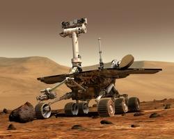 NASA's Spirit rover found a new
class of water-affected rock, while its twin, Opportunity, finished
inspecting its own heat shield and set a new Martian driving
record. The rovers successfully completed their three-month primary
missions in April 2004 and are working on extended exploration
missions.
NASA's Spirit rover found a new
class of water-affected rock, while its twin, Opportunity, finished
inspecting its own heat shield and set a new Martian driving
record. The rovers successfully completed their three-month primary
missions in April 2004 and are working on extended exploration
missions.
"This is probably the most interesting and important rock Spirit
has examined," said Dr. Steve Squyres of Cornell University,
Ithaca, N.Y., principal investigator for the rovers. The rock,
dubbed "Peace," is an exposure of bedrock in the Columbia Hills.
The hills are in Gusev Crater, where Spirit landed 13 months ago.
"This may be what the bones of this mountain are really made of. It
gives us even more compelling evidence for water playing a major
role for altering the rocks here," Squyres added.
Peace contains more sulfate salt than any other rock Spirit has
examined. Dr. Ralf Gellert, of Max-Planck-Institut fur Chemie,
Mainz, Germany, said, "Usually when we have seen high levels of
sulfur in rocks at Gusev, it has been at the very surface. The
unusual thing about this rock is that deep inside, the sulfur is
still very high. The sulfur enrichment at the surface is correlated
with the amount of magnesium, which points to magnesium
sulfate."
Observations by Spirit show the rock contains significant
amounts of the minerals olivine, pyroxene and magnetite, all of
which are common in some types of volcanic rock. The rock's texture
appears to be sand-size grains coated with a material loosely
binding the rock together. Spirit's rock abrasion tool dug about 1
centimeter deep (0.4 inch) in two hours.
"It looks as if you took volcanic rocks that were ground into
little grains, and then formed a layered rock with them cemented
together by a substantial quantity of magnesium-sulfate salt,"
Squyres said. "Where did the salt come from? We have two working
hypotheses we want to check by examining more rocks. It could come
from liquid water with magnesium sulfate salt dissolved in it,
percolating through the rock, then evaporating and leaving the salt
behind. Or it could come from weathering by dilute sulfuric acid
reacting with magnesium-rich minerals that were already in the
rock. Either case involves water."
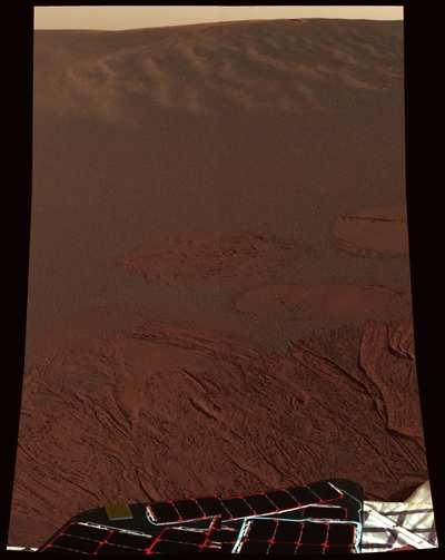
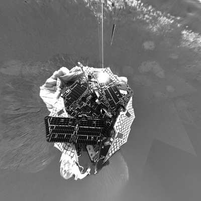
Opportunity used its microscopic imager to examine a cross
section of the heat shield that protected the spacecraft as it
slammed into Mars' atmosphere. This is the first time experts have
been able to examine a heat shield after it entered another
planet's atmosphere. Engineers expect the findings to aid design
for future missions.
"We've identified each broken piece of the heat shield. We know
there's a lot of data there, but we still need to analyze it," said
Ethiraj Venkatapathy of NASA's Ames Research Center, Moffett Field,
CA.
Christine Szalai, a spacecraft engineer at NASA's Jet Propulsion
Laboratory, Pasadena, CA, said, "We are examining the images to
determine the depth of charring in the heat shield material. In the
initial look, we didn't see any surprises. We will be working for
the next few months to analyze the performance of the heat
shield."
Since leaving the heat shield, Opportunity has been traveling
south to explore new sites. The rover set a single-day martian
driving record, covering 154.65 meters (507.4 feet) on Jan. 28. Two
days later, it drove even farther, 156.55 meters (513.6 feet). The
first 90 meters (295 feet) of each drive were performed in
blind-drive mode, following a route planners created from stereo
images from the rover and maps created from orbital imagery. The
rest was autonomous driving, with the rover choosing its own route
to avoid any hazards it perceived in stereo images taken along the
way.
"The terrain we're crossing is so flat we can see a long way
ahead," said JPL rover planner Frank Hartman, who teamed with Jeff
Biesiadecki to plot the drive. "Opportunity has paused for some
trenching, but in a few days we'll put the pedal to the metal
again."
 ANN's Daily Aero-Linx (04.15.24)

