Simulators On Site Receives FAA Certification | Aero-News Network
Aero-News Network
RSS icon RSS feed
podcast icon MP3 podcast
Subscribe Aero-News e-mail Newsletter Subscribe

Airborne Unlimited -- Most Recent Daily Episodes

Episode Date

Airborne-Monday

Airborne-Tuesday

Airborne-Wednesday Airborne-Thursday

Airborne-Friday

Airborne On YouTube

Airborne-Unlimited-04.01.24

Airborne-Unlimited-04.16.24

Airborne-FlightTraining-04.17.24 Airborne-Unlimited-04.11.24

Airborne-Unlimited-04.12.24

Join Us At 0900ET, Friday, 4/10, for the LIVE Morning Brief.
Watch It LIVE at
www.airborne-live.net

Tue, Jan 26, 2010

Simulators On Site Receives FAA Certification

Portable, Fully-Immersive Sim Contained In A 20-Foot Cargo Trailer

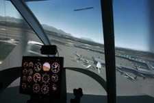
Simulators On Site (S.O.S) received full FAA certification AATD and BATD for generic helicopter simulator system in November, according to company owner and president Steve Nelson. The system is an immersive technology with a separate instructor station that is built in to an 18-20 foot cargo trailer. The first simulated cockpit environment is that of a Bell 206/407 Jet Ranger.


SOS Day Simulation Image Courtesy SOS

S.O.S. has patented what is known as a Surround Screen Simulator, which directly projects images onto a screen measuring 220 X 85 degrees. This system, which can also be replicated in a stationary office environment, was designed by and built by engineers who are pilots. Nelson, himself a flight instructor and FAA licensed engineer, says the simulator immerses the pilot in the environment. He says the pilot doesn't look into a single or multi flat screen CRT.

When asked by FAA inspector Lance Knuckles, "Why did you start with a helicopter?" Nelson said, "It was the hardest one to do and I figured if I do the hardest first the rest will be easy".

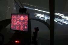
The S.O.S simulator uses a Garmin GPS unit. All cockpits will be designed to precisely replicate the simulated aircraft. The system allows multiple simulators to be networked, both locally and over the internet. Because of S.O.S.'s patented optical system, pilots can train on slope landings, tail in hover, nose in hover, and use of real night vision goggles. Nelson says because of the patented imaging of this simulator there is no distortion and no hot spots. It also eliminates 'stair-stepping' of the horizon, even with rapid maneuvers. Along with this immersive technology comes patented data feedback with vibrations and sound.


SOS Night Simulation Image Coutesy SOS

The instructors station is comprised of 6 separate screens to monitor all phases of pilot training. Three represent  "out the window" views, one is the instructors screen with mapping and instructor controls, one for viewing the trainee, and one to duplicate instrument panel inside the aircraft.

FAA certification was performed on X-PLANE platform Version 8.64 and above. S.O.S. offers sales as well as lease options, rentals, and says it will consider mobile scheduling of their portable units.

FMI: www.simulatorsonsite.com

Advertisement

More News

ANN's Daily Aero-Linx (04.15.24)

Aero Linx: International Flying Farmers IFF is a not-for-profit organization started in 1944 by farmers who were also private pilots. We have members all across the United States a>[...]

Classic Aero-TV: 'No Other Options' -- The Israeli Air Force's Danny Shapira

From 2017 (YouTube Version): Remembrances Of An Israeli Air Force Test Pilot Early in 2016, ANN contributor Maxine Scheer traveled to Israel, where she had the opportunity to sit d>[...]

Aero-News: Quote of the Day (04.15.24)

"We renegotiated what our debt restructuring is on a lot of our debts, mostly with the family. Those debts are going to be converted into equity..." Source: Excerpts from a short v>[...]

Airborne 04.16.24: RV Update, Affordable Flying Expo, Diamond Lil

Also: B-29 Superfortress Reunion, FAA Wants Controllers, Spirit Airlines Pulls Back, Gogo Galileo Van's Aircraft posted a short video recapping the goings-on around their reorganiz>[...]

ANN's Daily Aero-Term (04.16.24): Chart Supplement US

Chart Supplement US A flight information publication designed for use with appropriate IFR or VFR charts which contains data on all airports, seaplane bases, and heliports open to >[...]

blog comments powered by Disqus


Advertisement

Advertisement

Podcasts

Advertisement

© 2007 - 2024 Web Development & Design by Pauli Systems, LC