Also Adds Support For Three-Display Configuration And On-Board
Weather Radar
Avidyne Corporation has unveiled their soon-to-be-certified v9.3
software upgrade—including their innovative implementation of
Synthetic Vision technology (SVS)—for the award-winning
Entegra Release 9 Integrated Flight Deck (R9) system. The
v9.3 software release, which is expected to receive final FAA
certification later this year, also provides support for
three-screen R9 installations and on-board weather radar.
“Synthetic Vision provides a new level of situational
awareness for our R9 customers, and we have included some
innovative features that make this truly compelling and
intuitive,” said Patrick Herguth, Avidyne’s Chief
Operating Officer, in a news release Monday. “SVS also gives
pilots and passengers additional peace of mind by clearly
displaying nearby hazards—including terrain, obstacles, and
traffic—in a highly-accurate, full-color 3D presentation,
with dynamically-computed visual and aural alerts for added
safety.”
“Customers will find our SVS second to none in terms
innovative features that are easy to use and that dramatically
enhance situational awareness,” said Dan Schwinn,
Avidyne’s President and CEO. “Forward Looking Terrain
Alerting and an adjustable Field of View are great examples of how
Avidyne has designed a synthetic vision system that is truly
compelling and that R9 pilots will not want to fly
without.”
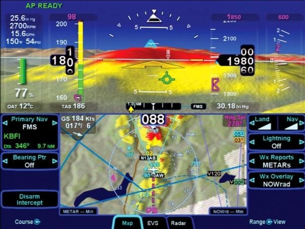
Avidyne’s SVS provides a graphical presentation of
three-dimensional terrain and water, obstacles, and traffic, and
includes the addition of a Total Velocity Vector (TVV) on the
primary flight display. The TVV provides a visual representation of
the aircraft flight path, indicating where the airplane is going
and not necessarily where the aircraft is pointing.
METAR-colored flags make it easy to locate airports in the 3D
scene, and based on the approach you have entered in the FMS, the
selected runway at your destination airport is highlighted for
additional clarity and ease of identification.
Avidyne’s SVS has an innovative selectable horizontal
field of view (FOV), which provides pilots with the ability to
adjust the 3D zoom setting of the terrain presentation on the
display. The default field of view is 45 degrees for normal
flight. However, a wide-angle 120-degree field of view
setting provides more ‘peripheral vision’ when
maneuvering in mountainous areas, while the 20-degree close-in view
might be used to zoom in on a distant airport, allowing you to
actually verify a runway heading from a greater distance
away.
SVS also provides color-coded Terrain Awareness that displays
yellow and red hashed-patterns overlaid on the terrain display
correlating with terrain that is 101 to 500 below your current
altitude (yellow) and terrain that is 100 feet below to anything
above your current altitude (red). Avidyne’s
unique Forward Looking Terrain Alerting (FLTA) feature provides an
extra measure of safety by dynamically displaying a solid yellow or
red impact point based on the projected flight path.
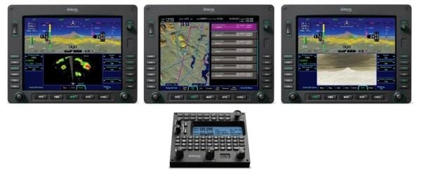
Version 9.3 software also supports cockpit configurations with
three-displays and on-board weather radar. Entegra Release 9
was designed with a versatile peer-to-peer data bus architecture
that easily enables expansion of cockpit configurations of two,
three, or more integrated flight displays (IFDs), while allowing
each display to have full access to all of the data of the others.
In a three-IFD system, like Avidyne is certifying for the Piper
Meridian, each IFD can display on-board weather radar and SVS
simultaneously, just as they all have access to other important
information like datalink weather, checklists, and engine
instrumentation.
“R9’s redundancy and safety benefits are unmatched
in the industry,” Schwinn added.
Existing owners of Entegra Release 9-equipped Cirrus SR20/SR22
and Piper Matrix aircraft will receive v9.3 software and the
Synthetic Vision upgrade free of charge. For new installation of
Entegra Release 9, the Synthetic Vision option can be enabled for
an additional $5,000 per display.
Version 9.3 software and SVS will be approved later this year,
and will also add the Piper PA-46 Mirage and Meridian models to the
growing list of Entegra Release 9-approved aircraft.
 ANN's Daily Aero-Linx (04.13.24)

