Company Develops EFIS Application For iPhone | Aero-News Network
Aero-News Network
RSS icon RSS feed
podcast icon MP3 podcast
Subscribe Aero-News e-mail Newsletter Subscribe

Airborne Unlimited -- Most Recent Daily Episodes

Episode Date

Airborne-Monday

Airborne-Tuesday

Airborne-Wednesday Airborne-Thursday

Airborne-Friday

Airborne On YouTube

Airborne-Unlimited-04.01.24

Airborne-Unlimited-04.09.24

Airborne-Unlimited-04.10.24 Airborne-Unlimited-04.11.24

Airborne-Unlimited-04.12.24

Join Us At 0900ET, Friday, 4/10, for the LIVE Morning Brief.
Watch It LIVE at
www.airborne-live.net

Sat, Oct 25, 2008

Company Develops EFIS Application For iPhone

iHUD Much Cheaper Than True Glass Panels... But It's Only For Show, For Now

Will there come a day when pilots will only need to plug an iPhone into the panels of their small planes to go flying? Well... probably not, though a new application presents a compelling argument for that possible future.

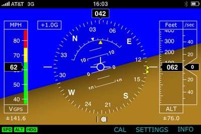
Dubbed the iHUD, the $5.99 download turns the iPhone "into an aerospace-inspired mobile Glass Cockpit," according to programmer Aero Visions International -- which hastens to add the application is merely for entertainment purposes, and is "not intended for steering airplanes, helicopters, boats, motorcycles, and other powered vehicles, and UFOs."

The app is indeed entertaining... particularly for pilot-types. Utilizing the iPhone's GPS receiver and accelerometers, iHUD presents a thoroughly realistic EFIS-like display of position, attitude, attitude changes, track and acceleration.

"iHUD depicts an extraordinary graphic interface with a simulated horizon and a vehicle reference symbol, dynamic speed, altitude, and vertical velocity ribbons and digital display window, rotating compass card with user selectable heading bug, slip/skid ball, and an accelerometer (G-meter)," the company writes. "iHUD offers a fantastic way to teach, see, and learn EFIS and partially AHRS on-the-fly."

Alas, this isn't the $6 alternative to installing a Garmin G600 (starting price $30,000) in your Skyhawk. Apart from the size issue -- sizewise, an iPhone EFIS would be proportional to a roughly 3/5-scale LSA -- there is a significant limitation to the current iHUD version, as horizon information is gleaned only from the accelerometers inside the iPhone.

"This means that the horizon does not display the earth horizon as a reference of a vehicle in an accelerated attitude," Aero Vision warns. "It will display the acceleration of the vehicle only. Therefore, never ever use this version of iHUD for in-flight operations to visualize attitude other than pitch and roll.

"We are currently studying the possibility to mathematically model an algorithm to address this issue," the company tantalizingly adds.

The application may also be downloaded to the iPod touch... though without a GPS receiver, only basic attitude information and G-force acceleration will be displayed.

FMI: www.i-hud.com/iHUD_suite.html

Advertisement

More News

ANN's Daily Aero-Linx (04.13.24)

Aero Linx: Florida Antique Biplane Association "Biplanes.....outrageous fun since 1903." That quote really defines what the Florida Antique Biplane Association (FABA) is all about.>[...]

ANN's Daily Aero-Term (04.13.24): Beyond Visual Line Of Sight (BVLOS)

Beyond Visual Line Of Sight (BVLOS) The operation of a UAS beyond the visual capability of the flight crew members (i.e., remote pilot in command [RPIC], the person manipulating th>[...]

Airborne 04.09.24: SnF24!, Piper-DeltaHawk!, Fisher Update, Junkers

Also: ForeFlight Upgrades, Cicare USA, Vittorazi Engines, EarthX We have a number of late-breaking news highlights from the 2024 Innovation Preview... which was PACKED with real ne>[...]

Aero-News: Quote of the Day (04.14.24)

“For Montaer Aircraft it is a very prudent move to incorporate such reliable institution as Ocala Aviation, with the background of decades in training experience and aviation>[...]

ANN's Daily Aero-Term (04.14.24): Maximum Authorized Altitude

Maximum Authorized Altitude A published altitude representing the maximum usable altitude or flight level for an airspace structure or route segment. It is the highest altitude on >[...]

blog comments powered by Disqus


Advertisement

Advertisement

Podcasts

Advertisement

© 2007 - 2024 Web Development & Design by Pauli Systems, LC