Online Database, Other Changes Since US Airways Flight 1549
Incident Last January
Following the US Airways Flight 1549 bird strike and emergency
landing in the Hudson River a year ago Friday, public interest in
the FAA’s wildlife mitigation efforts significantly
increased. However, the agency’s Office of Airports has
overseen a wildlife management program for nearly 50 years and has
conducted wide-ranging research to find the best ways to keep
airports safe by making them less attractive to all types of
wildlife. The FAA says it remains committed to its long-standing
goal of reducing wildlife hazards at or near our nation’s
airports. To reach that goal, the FAA regularly partners with
academia, military, other government agencies, and the aviation
industry to conduct research and outreach in this area. The FAA
manages airport wildlife hazards through a number of avenues
including regulation, agency guidance, advisory circulars and
ongoing education.
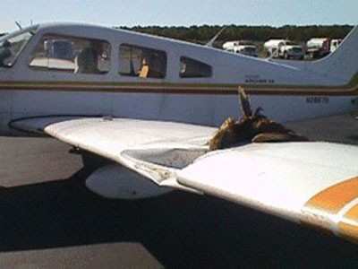
FAA Photo
On April 24 of last year, the FAA made
the bird strike database available to the public with a small
amount of data containing privacy information such as personal
phone numbers deleted. Prior to this, only portions of the database
were publicly available. The FAA began collecting data in the 1990s
for use by the FAA’s Office of Airports, academia, and
researchers as a means to improve airport safety and reduce
wildlife hazards.
According to the database, there have been over 100,000 (Civil
and USAF) wildlife strikes between 1990 and 2008. 92% of the bird
strikes occur at or below 3,000 ft AGL (above ground level), and
72% of bird-remains have not be identified to species level. Even
the space shuttle is not immune. It was determined that Space
Shuttle Discovery hit a turkey vulture during the take off of
STS-114 on July 26, 2005.
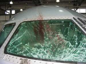
FAA Photo
The re-designed website allows users to
search the database for wildlife strike incidents, as well as
electronically file and edit strike reports. The database is
searchable by state, airport, or airline involved.
In a report released in December, SRA International, Inc., a
leading provider of information technology service, and Richard
Dolbeer, Ph.D., a world renowned wildlife hazard mitigation expert,
estimated that the total number of strikes reported has increased
from 20 percent during the period from 1990-1994 to 39 percent from
2004-2008. The majority of strike reports are filed at Part 139
airports, and approximately six percent at general aviation
airports. Although there is a higher level of reporting, the number
of damaging strikes has not increased mainly because many
certificated airports have successfully put in place
professionally-run wildlife hazard programs. Dolbeer determined the
current level of reporting (39 percent) is statistically valid and
is sufficient for the FAA to develop national trends and mitigation
policies. Based on those findings, Dolbeer concluded that mandatory
reporting is not required.
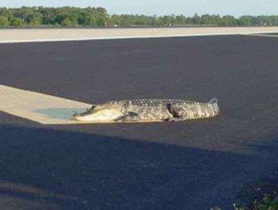
Alligator On Orlando Intl. Runway FAA Photo
The FAA has a number of ongoing
programs dedicated to wildlife near airports. The commercial avian
radar systems currently being assessed by the FAA are designed to
detect birds flying on and in the vicinity of an airport and to
provide information about the bird targets in terms of position and
direction of movement. The target information may be in the form of
text or visual display such as a map. The information can be used
to mitigate the risks associated with the bird activity and
aircraft safety.
 ANN's Daily Aero-Linx (04.13.24)

