Part Of A Multi-Year Effort To Measure Polar Ice
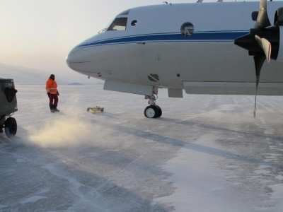
 Researchers and flight crew arrived
in Thule, Greenland, on Monday, March 14, for the start of NASA's
2011 Operation IceBridge, an airborne mission to study changes in
Arctic polar ice. This year's plans include surveys of Canadian ice
caps and expanded international collaboration. The state of Earth's
polar ice sheets, glaciers and sea ice is an important indicator of
climate change and plays a key role in regulating global climate.
With IceBridge, NASA is pushing ahead with its commitment to keep
an eye on changes to polar ice to better understand the effects of
climate change.
Researchers and flight crew arrived
in Thule, Greenland, on Monday, March 14, for the start of NASA's
2011 Operation IceBridge, an airborne mission to study changes in
Arctic polar ice. This year's plans include surveys of Canadian ice
caps and expanded international collaboration. The state of Earth's
polar ice sheets, glaciers and sea ice is an important indicator of
climate change and plays a key role in regulating global climate.
With IceBridge, NASA is pushing ahead with its commitment to keep
an eye on changes to polar ice to better understand the effects of
climate change.
Since 2009, Operation IceBridge has flown annual campaigns over
the Arctic starting in March and over Antarctica starting in
October. The mission extends the multi-year record of ice elevation
measurements made by NASA's Ice Cloud and land Elevation Satellite
(ICESat), which stopped collecting data in 2009, and the upcoming
ICESat-2, scheduled for launch in 2016. "Each successive IceBridge
campaign has broadened in scope," said IceBridge project scientist
Michael Studinger of Goddard Earth Sciences and Technology Center
at the University of Maryland. "This year, we have more flight
hours and flight plans than ever before. We are looking forward to
a busy, fruitful campaign."
The first science flight is scheduled for this week, pending
favorable weather. For almost 10 weeks, researchers will operate an
array of airborne instruments collecting data over Arctic land and
sea ice. Among the highest priority flights is an overnight transit
to Fairbanks, AK, to collect sea ice thickness data across a slice
of the Arctic Ocean. Sea ice is thought to be thinning in recent
years in addition to shrinking in the area covered. Another
high-priority flight plan is to fly over the Barnes and Devon ice
caps of the Canadian Arctic Archipelago.
"The Canadian ice caps are notably smaller than the Greenland
and Antarctic ice sheets, but are still significant potential
contributors to sea-level change in the next few decades," said
Charles Webb, deputy cryosphere program manager at NASA's Goddard
Space Flight Center in Greenbelt, Md. "They also serve as potential
early-warning indicators, responding more sensitively to
temperature changes than the more massive ice sheets."
NASA Image
The IceBridge campaign also plans to fly for the first time over
the European Space Agency's ground-based calibration sites for
their ice-observing satellite, CryoSat-2. Flights over calibration
sites ultimately are expected to provide data to evaluate and
improve remote-sensing measurements. Still other IceBridge missions
will retrace paths flown in previous years, such as flights over
Petermann, Jacobshavn, Kangerlussuak and Helheim glaciers. With
this multi-year data, scientists can begin to see how such glaciers
-- the outlets through which Greenland loses mass from its ice
sheet -- are changing, where ice loss is slowing or accelerating,
and why.
The P-3B aircraft from NASA's Wallops Flight Facility in Wallops
Island, VA, will fly from Thule and Kagerlussuaq, Greenland,
carrying a suite of instruments. The Airborne Topographic Mapper
measures changes in the surface elevation of the ice by reflecting
lasers from the ground back to the aircraft and converting the
readings into elevation maps. Radar instruments onboard the P-3B
from the University of Kansas' Center for Remote Sensing of Ice
Sheets in Lawrence, KS., allow scientists to see snow and ice
characteristics at the surface and down to the bedrock. A gravity
instrument from Columbia University's Lamont-Doherty Earth
Observatory in Palisades, NY, is used to peer below floating ice to
determine the shape of water-filled cavities below. Another laser
altimeter, the Land, Vegetation, and Ice Sensor, operates at higher
altitudes to survey large areas. This altimeter will fly solo out
of Kangerlussuaq on the King Air B-200, an aircraft based at NASA's
Langley Research Center in Hampton, VA.
The IceBridge campaign is led by Goddard. The Earth Science
Project Office at NASA's Ames Research Center in Moffett Field, CA,
is responsible for integration of science experiments on the
aircraft and mission logistics.
 ANN's Daily Aero-Linx (04.13.24)

