Jeppesen Unveils New Logo, Product At AirVenture 2008 | Aero-News Network
Aero-News Network
RSS icon RSS feed
podcast icon MP3 podcast
Subscribe Aero-News e-mail Newsletter Subscribe

Airborne Unlimited -- Most Recent Daily Episodes

Episode Date

Airborne-Monday

Airborne-Tuesday

Airborne-Wednesday Airborne-Thursday

Airborne-Friday

Airborne On YouTube

Airborne-Unlimited-04.01.24

Airborne-Unlimited-04.16.24

Airborne-FlightTraining-04.17.24 Airborne-Unlimited-04.11.24

Airborne-Unlimited-04.12.24

Join Us At 0900ET, Friday, 4/10, for the LIVE Morning Brief.
Watch It LIVE at
www.airborne-live.net

Tue, Jul 29, 2008

Jeppesen Unveils New Logo, Product At AirVenture 2008

New VFR+GPS Nav Chart Billed As "Perfect VFR Chart"

Jeppeson unveiled its new corporate logo reflecting the evolution of its products and services, as well as its expansion into all transportation markets. Known for its aeronautical navigational products, now they offer an array of solutions for land and sea operations as well.

The logo is known as The Edge. The transition from an airplane silhouette into a series of stacked shapes represents Jeppesen's forward movement. Mark Van Tine, Jeppesen president and CEO, says, "I believe our new logo communicates the image we want the people to embrace when they think of Jeppesen... for our long-standing aviation customers, the message is that we are much more than 'just that old chart company.'"

In the coming months, the logo will be rolled out across its products and in a new website, currently under development.

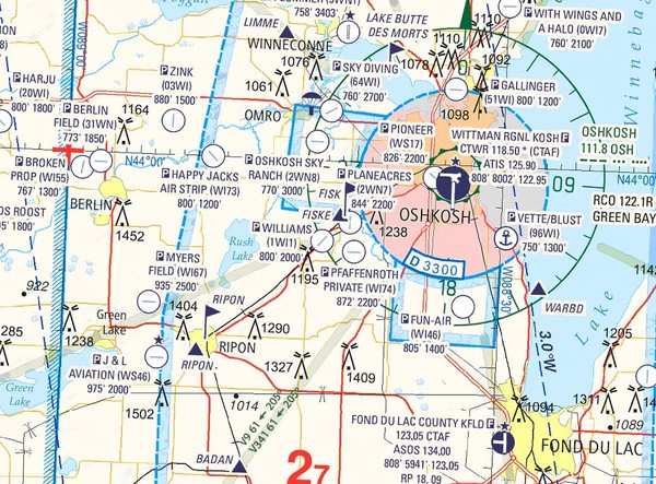
Jeppesen also announced the release of the new VFR+GPS charts for navigation in North America. Initially developed in Europe many years ago, it is a clean-sheet design. Incorporating color and contrast to make a VFR chart easier to read and interpret, it also adds GPS elements, such as all airport identifiers and GPS waypoints.

The depiction of Class B, C, D and E airspace is much more easily understood, with altitude limits clearly shown. Data from NAVTEQ provides the latest information on roads, cities, and points of interest easily identified from the air. Terrain data from the Space Shuttle radar missions provide a realistic depiction of the earth below. State-of-the-art charting tools combine the data for a clean, intuitive look. JeppGuide airport diagrams are on the back of each chart.

Christopher Dean, product manager for business and general aviation at Jeppesen, briefed the media on the new charts. "The new charts were designed by pilots for pilots," says Dean. "It's the perfect VFR chart."

The new coverage areas will initially include enroute and area charts from Miami to Atlanta. Launch kits will be sent to area FBOs next week. Expansion to other areas across the lower 48 states of the US will be completed by late 2009. The latest enroute chart offered covers Wisconsin and Illinois, which will be featured as a Special Oshkosh Commemorative Chart during AirVenture at the Jeppesen booth.

The initial cost of the charts will be $9.95 for the enroute charts and $5.95 for the area charts. A digital rollout will occur once all the North American charts are completed.

FMI: www.jeppesen.com

Advertisement

More News

ANN's Daily Aero-Linx (04.15.24)

Aero Linx: International Flying Farmers IFF is a not-for-profit organization started in 1944 by farmers who were also private pilots. We have members all across the United States a>[...]

Classic Aero-TV: 'No Other Options' -- The Israeli Air Force's Danny Shapira

From 2017 (YouTube Version): Remembrances Of An Israeli Air Force Test Pilot Early in 2016, ANN contributor Maxine Scheer traveled to Israel, where she had the opportunity to sit d>[...]

Aero-News: Quote of the Day (04.15.24)

"We renegotiated what our debt restructuring is on a lot of our debts, mostly with the family. Those debts are going to be converted into equity..." Source: Excerpts from a short v>[...]

Airborne 04.16.24: RV Update, Affordable Flying Expo, Diamond Lil

Also: B-29 Superfortress Reunion, FAA Wants Controllers, Spirit Airlines Pulls Back, Gogo Galileo Van's Aircraft posted a short video recapping the goings-on around their reorganiz>[...]

ANN's Daily Aero-Term (04.16.24): Chart Supplement US

Chart Supplement US A flight information publication designed for use with appropriate IFR or VFR charts which contains data on all airports, seaplane bases, and heliports open to >[...]

blog comments powered by Disqus


Advertisement

Advertisement

Podcasts

Advertisement

© 2007 - 2024 Web Development & Design by Pauli Systems, LC