53rd Weather Reconnaissance Squadron Will Fly First Winter
Storm
 This only seems appropriate after a blizzard dumped record
snowfall along the eastern seaboard last week, though it might give
an entirely new meaning to "known icing conditions". Members of the
53rd Weather Reconnaissance Squadron at Keesler AFB in Mississippi
have been tasked by National Weather Service officials to fly their
first winter storm of the season on the East Coast starting
Christmas day.
This only seems appropriate after a blizzard dumped record
snowfall along the eastern seaboard last week, though it might give
an entirely new meaning to "known icing conditions". Members of the
53rd Weather Reconnaissance Squadron at Keesler AFB in Mississippi
have been tasked by National Weather Service officials to fly their
first winter storm of the season on the East Coast starting
Christmas day.
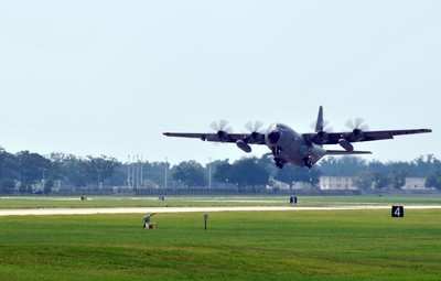
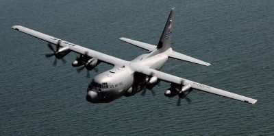
The Air Force Reserve's 53rd WRS "Hurricane Hunters," assigned
to the 403rd Wing here, normally collect weather data during
tropical storms, enabling forecasters to make more accurate
predictions. Between hurricane seasons, the Hurricane Hunters have
a lesser known, but equally important role: collecting weather data
during winter storms. "Whenever there's a system track that will
cause an impact, there's potential for winter storms," said Lt.
Col. Jon Talbot, a 53rd WRS aerial reconnaissance weather officer
since 1992.
To prepare for a winter storm flying mission, the Hurricane
Hunters carefully plan the mission, review which flying route they
will take and make altitude reservations by coordinating with air
traffic control, said Lt. Col. Roy Deatherage, a 53rd WRS aerial
reconnaissance weather officer. "The National Weather Service runs
computer models that forecast the weather three to five days in
advance of a storm," Colonel Talbot said. As an aerial
reconnaissance weather officer, he acts as a mission director and
liaison between the National Weather Service and his crew. "Winter
storms have a lot of impact," he said, detailing the emergency
services and salt trucks that are used once the threat of a winter
storm has been confirmed.
The Hurricane Hunters have two winter storm missions, Colonel
Talbot said. The first is the Pacific mission. "We average 20
missions over 30 days when we deploy our airplanes to either Alaska
or Hawaii." The second is flying winter storms locally in the Gulf
of Mexico and in the Atlantic Ocean. "The goal is to improve the
weather forecast for the East Coast because we have a lot of people
and money tied up in the Washington to Boston corridor," Colonel
Talbot said.
The return of investment for flying winter storms and collecting
data is an estimated 15 percent greater accuracy in weather
forecasting. "There are some 5,000 salt trucks in New York City
alone," Colonel Talbot said. The increase in forecasting accuracy
directly impacts emergency management capabilities by reducing the
unnecessary dispatch of resources, which can be costly. "If you
collect the right information at the right place -- over the
Pacific Ocean -- you can make a big impact to the forecast four to
five days later," Colonel Talbot said. The idea is to fly winter
storms before they happen to make the forecast better for the
entire Northeastern community.
Colder weather at high altitudes presents a unique challenge to
the Hurricane Hunters since the crew must remain cognizant of
icing, said Maj. Kevin Fryar, a 53rd WRS aerial reconnaissance
weather officer. The Hurricane Hunters fly WC-130Js at high
altitudes, typically 5 to 10,000 feet above their normal range, and
drop small weather canisters, or dropsondes, designed to collect
weather data in key locations of high-weather activity.
Weather information collected from the dropsondes is then
transmitted to the National Weather Service and is ultimately used
by forecasters to assess weather patterns enabling them to forecast
more accurately. In a storm, data is transmitted to the National
Weather Agency and is later passed on to the Air Force Weather
Network, Colonel Talbot said. "When you fly a hurricane mission,
you know you're making a difference," Colonel Talbot said. "With
this mission, we know there are people waiting for the information
we give to make the best possible forecast. It's essentially the
same thing (as a hurricane mission)."
To Colonel Talbot, a 24-year veteran to the weather field, the
experience is as rewarding as it is beneficial. "What other
meteorologists get to fly? You get the best of both worlds." he
said.
To the people waiting for the forecast, the information he
collects can mean the difference between spending hundreds of
thousands in preparing for the weather rather than millions of
dollars reacting to it.
ANN Salutes Senior Airman Kimberly Erickson, 403rd Wing Public
Affairs
 ANN's Daily Aero-Linx (04.13.24)

