Getting There Once You Leave The Airport | Aero-News Network
Aero-News Network
RSS icon RSS feed
podcast icon MP3 podcast
Subscribe Aero-News e-mail Newsletter Subscribe

Airborne Unlimited -- Most Recent Daily Episodes

Episode Date

Airborne-Monday

Airborne-Tuesday

Airborne-Wednesday Airborne-Thursday

Airborne-Friday

Airborne On YouTube

Airborne-Unlimited-04.01.24

Airborne-Unlimited-04.16.24

Airborne-FlightTraining-04.17.24 Airborne-Unlimited-04.11.24

Airborne-Unlimited-04.12.24

Join Us At 0900ET, Friday, 4/10, for the LIVE Morning Brief.
Watch It LIVE at
www.airborne-live.net

Thu, Jun 17, 2004

Getting There Once You Leave The Airport

Control Vision Introduces Street Mapping

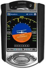
The considerable army of Anywhere Map and Wx owners have several things in common-one is the dilemma when they land their aircraft, hop in a car and pick out restaurant or hotel to drive to. They generally have to ask directions (unless they've landed at their home airport). They may get to their secondary destination without a hitch, but more likely, they will have to stop and ask for more directions if it's not a late night or it isn't raining.

Now Anywhere Map extends the power of GPS mapping to North America's roads with a powerful new PDA called the Mio 168, with an amazingly detailed map of roads and points of interest. The street mapping utility is available from Control Vision as a complete ready-to-fly-and-drive system, or as a software upgrade for existing Anywhere Map customers.        

As a complete system, the Mio 168 includes a powerful 300 MHz PDA, a built-in 12-channel GPS, Mio Map� street mapping application, and the pilot's choice of Control Vision applications from Anywhere Map to Pocket Plates. The Mio's built-in SD (Secure Digital) slot enables data storage for Mio Map and Pocket Plates on inexpensive memory cards. Pricing for an Anywhere-equipped Mio with Mio Map software is $845.00.

The Mio's 3.5 inch screen shows 65,000 colors and is approximately the same size as HP's 2200 series. It is visible in sunlight, diminished light and darkness. Its North American street mapping program, Mio Map�, calculates a route from your present position in seconds, displaying the route in a flat map view, a 3-D perspective view or a bird's eye view, all the while calling out directions giving you up to two miles to prepare for a turn or an exit from an expressway. The Mio ships with all the software necessary for installation, a suction-cup mount for a vehicle, a cigarette lighter power supply, and an earphone for listening to the clear voice directions given.

For existing Anywhere Map customers, Control Vision offers Destinator�, the software equivalent of Mio Map that can be installed on any Control Vision PDA with a memory card. The Destinator software package is available for $189.00.

Anywhere Map pilots who wish to add the Mio 168 as a backup to their current Anywhere Map system may take advantage of the Anywhere Map software license which permits installing the moving map program on two PDAs under the owner's control.

FMI: www.controlvision.com

Advertisement

More News

ANN's Daily Aero-Linx (04.15.24)

Aero Linx: International Flying Farmers IFF is a not-for-profit organization started in 1944 by farmers who were also private pilots. We have members all across the United States a>[...]

Classic Aero-TV: 'No Other Options' -- The Israeli Air Force's Danny Shapira

From 2017 (YouTube Version): Remembrances Of An Israeli Air Force Test Pilot Early in 2016, ANN contributor Maxine Scheer traveled to Israel, where she had the opportunity to sit d>[...]

Aero-News: Quote of the Day (04.15.24)

"We renegotiated what our debt restructuring is on a lot of our debts, mostly with the family. Those debts are going to be converted into equity..." Source: Excerpts from a short v>[...]

Airborne 04.16.24: RV Update, Affordable Flying Expo, Diamond Lil

Also: B-29 Superfortress Reunion, FAA Wants Controllers, Spirit Airlines Pulls Back, Gogo Galileo Van's Aircraft posted a short video recapping the goings-on around their reorganiz>[...]

ANN's Daily Aero-Term (04.16.24): Chart Supplement US

Chart Supplement US A flight information publication designed for use with appropriate IFR or VFR charts which contains data on all airports, seaplane bases, and heliports open to >[...]

blog comments powered by Disqus


Advertisement

Advertisement

Podcasts

Advertisement

© 2007 - 2024 Web Development & Design by Pauli Systems, LC