Sandia Aerospace Debuts Air Data Computer | Aero-News Network
Aero-News Network
RSS icon RSS feed
podcast icon MP3 podcast
Subscribe Aero-News e-mail Newsletter Subscribe

Airborne Unlimited -- Most Recent Daily Episodes

Episode Date

Airborne-Monday

Airborne-Tuesday

Airborne-Wednesday Airborne-Thursday

Airborne-Friday

Airborne On YouTube

Airborne-Unlimited-04.01.24

Airborne-Unlimited-04.09.24

Airborne-Unlimited-04.10.24 Airborne-Unlimited-04.11.24

Airborne-Unlimited-04.12.24

Join Us At 0900ET, Friday, 4/10, for the LIVE Morning Brief.
Watch It LIVE at
www.airborne-live.net

Wed, Jul 20, 2005

Sandia Aerospace Debuts Air Data Computer

Just In Time For OSH

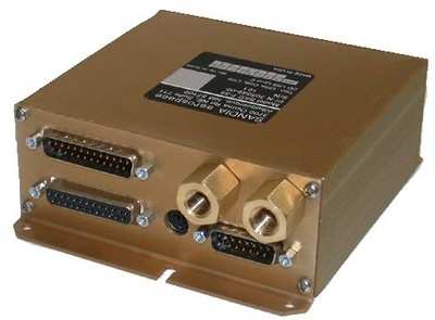
Sandia Aerospace is debuting its new SAC 7-35 Air Data Computer at AirVenture 2005.

Today's integrated Navigation Systems, such as Garmin's GNS 430 and GNS 530 have built-in capabilities that until now have been inaccessible by the majority of system owners. The SAC 7-35 provides the pilot with information to help plan and execute his flight. Operational to 35,000 feet, the SAC 7-35 is being certified as an Altitude Encoder for use with on board transponders, a Fuel Flow System and an Air Data Computer.

The SAC 7-35 accepts Pitot, Static, Heading, Track, Fuel Flow, Outside Air Temperature and Baro Correction. When interfaced to the GNS 430 or GNS530 it provides real time display of Wind Direction and Velocity, Density Altitude, Baro Corrected Altitude, Fuel Flow and Out Side Air Temperature and True Air Speed. The wind information can help the pilot select the best altitude to ensure the most favorable winds.

Sandia says this translates into better fuel economy which is increasingly important considering today's rising fuel prices. The density altitude information can aid the pilot in determining if takeoff distance. The fuel flow information aids the pilot in fuel management procedures and will alert him should fuel become critical. Keeping an eye on the Outside Air Temperature can alert the pilot to possible icing conditions.

The SAC 7-35 has multiple altitude outputs, including Grey Code for Mode C and Mode S transponders, dual RS232 pressure altitude outputs for modern transponders and legacy GPS systems, dual RS232 Air Data outputs for onboard navigations systems and an ARINC 429 Air Data Output.

The SAC 7-35 also incorporates Sandia Aerospace's Altitude In-flight Monitor (AIM) feature. AIM keeps a constant eye on the pilot's selected cruise altitude and advises him should the aircraft stray off altitude. When the pilot reaches his desired altitude, he simply presses the panel mounted AIM push-button and the annunciator displays the legend 'SET' to let him know that he has set his altitude into the SAC 7-35 's memory. If he deviates more than 100 feet, the AIM annunciator will display the legend 'ALT'. If he strays more than 200 feet, the 'ALT' legend will begin to flash.

FMI: www.sandiaaerospace.com

Advertisement

More News

ANN's Daily Aero-Linx (04.13.24)

Aero Linx: Florida Antique Biplane Association "Biplanes.....outrageous fun since 1903." That quote really defines what the Florida Antique Biplane Association (FABA) is all about.>[...]

ANN's Daily Aero-Term (04.13.24): Beyond Visual Line Of Sight (BVLOS)

Beyond Visual Line Of Sight (BVLOS) The operation of a UAS beyond the visual capability of the flight crew members (i.e., remote pilot in command [RPIC], the person manipulating th>[...]

Airborne 04.09.24: SnF24!, Piper-DeltaHawk!, Fisher Update, Junkers

Also: ForeFlight Upgrades, Cicare USA, Vittorazi Engines, EarthX We have a number of late-breaking news highlights from the 2024 Innovation Preview... which was PACKED with real ne>[...]

Aero-News: Quote of the Day (04.14.24)

“For Montaer Aircraft it is a very prudent move to incorporate such reliable institution as Ocala Aviation, with the background of decades in training experience and aviation>[...]

ANN's Daily Aero-Term (04.14.24): Maximum Authorized Altitude

Maximum Authorized Altitude A published altitude representing the maximum usable altitude or flight level for an airspace structure or route segment. It is the highest altitude on >[...]

blog comments powered by Disqus


Advertisement

Advertisement

Podcasts

Advertisement

© 2007 - 2024 Web Development & Design by Pauli Systems, LC