Pilot "Collided With Rising Terrain" While Fighting Hoyt Fire
In Nevada
 The NTSB has issues a preliminary report in the August 20th
accident in which an Air Tractor engaged in a firefighting mission
crashed, killing the pilot.
NTSB Identification: WPR09GA407
14 CFR Public Use
Accident occurred Thursday, August 20, 2009 in Austin, NV
Aircraft: AIR TRACTOR AT-802A, registration: N807MA
Injuries: 1 Fatal.
This is preliminary information, subject to change, and may
contain errors. Any errors in this report will be corrected when
the final report has been completed.
On August 20, 2009, about 1545 Pacific daylight time, an Air
Tractor AT-802A, N807MA, Bureau of Land Management (BLM)
designation T-857, collided with rising terrain during an attempted
fire retardant drop at the Hoyt fire, near Austin, Nevada.
Minuteman Aerial Application, Inc., owned the airplane. The BLM,
U.S. Department of the Interior (DOI), was operating the airplane
under the provisions of 14 Code of Federal Regulations (CFR) Part
91 with a restricted category FAA airworthiness certificate as a
public-use fire suppression flight. The pilot, the sole occupant,
was killed. The airplane was destroyed by impact forces. The flight
departed Battle Mountain Airport, Battle Mountain, Nevada, at 1513.
Visual meteorological conditions prevailed, and a BLM flight plan
had been filed.
The accident pilot was assigned the task of dropping fire
retardant onto a saddle area located along the intersection of two
perpendicular ridgelines.
Multiple witnesses located both on the ground, and in the air,
observed the accident airplane approach the designated drop area
from the south. Their accounts describe the airplane approaching
the drop area, but not releasing its load of retardant. Shortly
thereafter, the airplane made contact with rising terrain within
the saddle area. The airplane continued uphill, while still in
contact with the ground, towards a crest where the terrain dropped
away. The airplane then departed the end of the crest, descended,
and collided with terrain in the valley area below.
A witness, located on a ridge overlooking the saddle area from
the east, observed an airplane make a drop along the ridgeline. He
estimated the airplane to be flying about 200 feet above ground
level (agl) when it made its drop. A few seconds later he observed
the accident airplane fly along a similar heading, but at a lower
altitude. He stated that he was immediately concerned because the
airplane was approaching rising terrain. The airplane then
disappeared behind the ridgeline, and out of his view. A few
seconds later he observed the airplane, "launch" from the end of
the ridgeline, "tumble" and collide with terrain below.
The low-wing, tailwheel equipped, fixed-gear airplane, was
manufactured in 2003. It was powered by a Pratt and Whitney PT6A
turboprop engine, and equipped with a 5 blade constant-speed
propeller. It was additionally equipped with an 800-gallon hopper,
and a Turbine Conversions Ltd., hydraulic controlled fire gate.
The accident site was located at the northern edge of the Clan
Alpine Mountain Range, 34 miles northwest of Austin. The site was
characterized by dirt and rocky terrain dispersed with brush and
trees ranging in height from 3 to 5 feet.
The first identified point of contact (FIPC) consisted of two,
225-feet-long ground scars located at an elevation of about 6,450
feet msl. The scars continued to travel up rising terrain, on a
heading of 330 degrees magnetic. The spacing between the scars
corresponded to the dimension of the airplane’s two main
landing gear. Trees located within the immediate vicinity of the
scars were severed at the 4-foot level. Seven, 2-feet-long diagonal
slash marks were observed between the main scars, 100 feet from the
FIPC. The spacing of the slashes ranged between 14 and 48 inches. A
twisted fragment of propeller blade tip was located 20 feet west of
the markings.

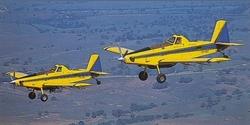
Air Tractor 802 File Photo
The two main ground scars continued until the terrain crested at
an elevation of about 6,570 feet, and dropped away. The main
wreckage was located about 760 feet beyond the crest at an
elevation of about 6,460 feet. The debris path from the crest to
the main wreckage consisted of the left main landing gear and wing
rib fragments.
The main wreckage site was characterized by a 30-foot-long
ground disruption on a heading of 350 degrees, followed by a
100-foot debris path to the fuselage, wings, and engine. The aft
elevator push-pull tube and fragments of the belly mounted hopper
gate doors were located within the initial disruption. Fire
retardant enveloped the entire wreckage area, and the odor of jet
fuel was present throughout the site.
 ANN's Daily Aero-Linx (04.15.24)
 Classic Aero-TV: 'No Other Options' -- The Israeli Air Force's Danny Shapira
 Aero-News: Quote of the Day (04.15.24)
 Airborne 04.16.24: RV Update, Affordable Flying Expo, Diamond Lil
 ANN's Daily Aero-Term (04.16.24): Chart Supplement US


