Mon, Jul 26, 2010
Jeppesen Charts Available Soon For Portable GPS
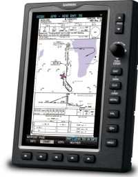
Garmin International's new and enhanced chart capabilities for
the GPSMAP 695/696 have been introduced Monday at AirVenture. This
top-of-the-line aviation portable will soon include georeferenced
Garmin FliteCharts, and cutomers also have the opportunity to
immediately subscribe to and receive Garmin’s georeferenced
ChartView powered by Jeppesen.
“We constantly solicit customer feedback in order to make
our products better, and these enhancements are a direct result of
customers’ requests for georeferenced charts,” said
Gary Kelley, Garmin’s vice president of marketing. “The
696 has a large, 7-inch portrait screen that is ideal for viewing
an entire approach plate. Now, pilots will be able to see their
aircraft’s exact position while monitoring other important
information on the approach
charts.”
Garmin FliteCharts is an electronic version of the National
Aeronautical Navigation Services Charts (AeroNav Services), which
was formerly NACO. FliteCharts lets pilots quickly find and view
all AeroNav Services Departure Procedures (DP), Standard Terminal
Arrival Routes (STARs), approach charts, and airport diagrams. If
the current approach is known, the GPSMAP 695/696 automatically
selects the correct chart based on the flight plan. Pilots will
have access to all approach plates currently published by AeroNav,
which encompasses over 15,000 charts and over 2,900 airports in the
U.S. FliteCharts updates are available from Garmin every 28 days,
and the new georeferenced capability will be included with the
regular updates.
ChartView brings an electronic version of Jeppesen’s
extensive, worldwide library of JeppView charts and airport
diagrams directly to the GPSMAP 695/696. ChartView displays
approach charts, arrival and departure procedures, and airport
diagrams.
Updates are available from Jeppesen every 14 days. The new
georeferenced version of Garmin FliteCharts will be available in
the fourth quarter 2010. FliteChart’s georeferenced support
is included in the standard FliteChart update. ChartView is
available immediately and will require a one-time additional $499
enabling key via fly.garmin.com, as well as the latest free device
software.
More News
Light Gun A handheld directional light signaling device which emits a brilliant narrow beam of white, green, or red light as selected by the tower controller. The color and type of>[...]
"The journey to this achievement started nearly a decade ago when a freshly commissioned Gentry, driven by a fascination with new technologies and a desire to contribute significan>[...]
Aero Linx: JAARS, Inc. For decades now, we’ve landed planes on narrow rivers and towering mountains. We’ve outfitted boats and vehicles to reach villages that rarely se>[...]
"Our driven and innovative team of military and civilian Airmen delivers combat power daily, ensuring our nation is ready today and tomorrow." Source: General Duke Richardson, AFMC>[...]
Aircraft Conflict Predicted conflict, within EDST of two aircraft, or between aircraft and airspace. A Red alert is used for conflicts when the predicted minimum separation is 5 na>[...]
 ANN's Daily Aero-Term (04.20.24): Light Gun

