The Final Moments Of Groton-Bound Lear 35 | Aero-News Network
Aero-News Network
RSS icon RSS feed
podcast icon MP3 podcast
Subscribe Aero-News e-mail Newsletter Subscribe

Airborne Unlimited -- Most Recent Daily Episodes

Episode Date

Airborne-Monday

Airborne-Tuesday

Airborne-Wednesday Airborne-Thursday

Airborne-Friday

Airborne On YouTube

Airborne-Unlimited-04.01.24

Airborne-Unlimited-04.09.24

Airborne-Unlimited-04.10.24 Airborne-Unlimited-04.11.24

Airborne-Unlimited-04.12.24

Join Us At 0900ET, Friday, 4/10, for the LIVE Morning Brief.
Watch It LIVE at
www.airborne-live.net

Mon, Aug 18, 2003

The Final Moments Of Groton-Bound Lear 35

Crew Apparently Tried To Power Out Of Trouble

Witnesses quoted by the NTSB in its preliminary report indicate the crew on board a doomed Lear 35 apparently tried to power their way out of trouble, but were unable to escape. One witness told the Board, the sound of the engines spooling up so close to the ground was “like it was a last-chance effort.”

The Learjet 35 was on its way to Groton (CT) from Farmington (NY) on August 4, when it canceled IFR about five miles from the airport in Groton. The NTSB says that was the last communication anyone on the ground had with the Lear. The tower at Groton wasn't staffed at the time of the incident, according to investigators.

The NTSB's initial report said that about 2 miles northeast of the airport's runway, the plane made a left turn. About 1.5 miles from the runway, and south of the extended runway centerline, the airplane turned left and back toward the right. When the plane was about an eighth of a mile south of the runway, it made a 60-degree right turn back toward the runway. The plane crossed the runway at an altitude of 200 feet, and began a left turn toward the center of the airport. The turn continued, and the airplane re-entered a left downwind for the runway, about 1,100 feet south of the runway, at an altitude of 300 feet. The last radar target was observed at 6:38 a.m. about an eighth of a mile northeast of the runway.

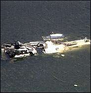
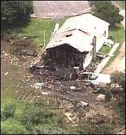
The plane hit the rooftop of a single-story house about a quarter-mile northeast of the approach end of runway 23, according to the NTSB, and continued for about 800 feet through a small line of hardwood and evergreen trees. It hit a second house, another line of trees, a third house, went down an embankment, and through a boardwalk, before coming to rest in the Poquonnock River. Two of the homes, two automobiles, and five boats moored on the river were destroyed by fire.

A portion of the right wing fuel tank was located in the yard of the third house with several long scratches that matched marks in the rooftop flashing of the first house hit. More wreckage was recovered from yards and the river.

Pilot Jerrod Katt, 33, and co-pilot Kenneth Hutchinson, 56, who were flying for Air East Management, died in the crash. No one on the ground was seriously hurt.

The cockpit voice and data recorders are now being analyzed at the NTSB's lab in Washington (DC).

FMI: www.ntsb.gov/ntsb/brief.asp?ev_id=20030814X01339&key=1

Advertisement

More News

ANN's Daily Aero-Linx (04.13.24)

Aero Linx: Florida Antique Biplane Association "Biplanes.....outrageous fun since 1903." That quote really defines what the Florida Antique Biplane Association (FABA) is all about.>[...]

ANN's Daily Aero-Term (04.13.24): Beyond Visual Line Of Sight (BVLOS)

Beyond Visual Line Of Sight (BVLOS) The operation of a UAS beyond the visual capability of the flight crew members (i.e., remote pilot in command [RPIC], the person manipulating th>[...]

Airborne 04.09.24: SnF24!, Piper-DeltaHawk!, Fisher Update, Junkers

Also: ForeFlight Upgrades, Cicare USA, Vittorazi Engines, EarthX We have a number of late-breaking news highlights from the 2024 Innovation Preview... which was PACKED with real ne>[...]

Aero-News: Quote of the Day (04.14.24)

“For Montaer Aircraft it is a very prudent move to incorporate such reliable institution as Ocala Aviation, with the background of decades in training experience and aviation>[...]

ANN's Daily Aero-Term (04.14.24): Maximum Authorized Altitude

Maximum Authorized Altitude A published altitude representing the maximum usable altitude or flight level for an airspace structure or route segment. It is the highest altitude on >[...]

blog comments powered by Disqus


Advertisement

Advertisement

Podcasts

Advertisement

© 2007 - 2024 Web Development & Design by Pauli Systems, LC