Boeing Launches GeoEye-1 Earth-Imaging Satellite | Aero-News Network
Aero-News Network
RSS icon RSS feed
podcast icon MP3 podcast
Subscribe Aero-News e-mail Newsletter Subscribe

Airborne Unlimited -- Most Recent Daily Episodes

Episode Date

Airborne-Monday

Airborne-Tuesday

Airborne-Wednesday Airborne-Thursday

Airborne-Friday

Airborne On YouTube

Airborne-Unlimited-04.01.24

Airborne-Unlimited-04.09.24

Airborne-Unlimited-04.10.24 Airborne-Unlimited-04.11.24

Airborne-Unlimited-04.12.24

Join Us At 0900ET, Friday, 4/10, for the LIVE Morning Brief.
Watch It LIVE at
www.airborne-live.net

Sun, Sep 07, 2008

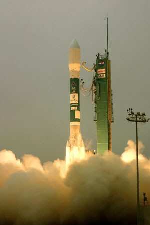
Boeing Launches GeoEye-1 Earth-Imaging Satellite

Boeing's commercial launch business has successfully launched the GeoEye-1 satellite today aboard a Delta II rocket procured from United Launch Alliance (ULA). Liftoff occurred, Saturday, at 11:50 a.m. Pacific time from launch pad SLC-2W at Vandenberg Air Force Base, Calif. The ULA Delta II rocket deployed the spacecraft approximately 58 minutes after liftoff.

GeoEye-1 will have the highest resolution of any commercial imaging system, capable of collecting images with a ground resolution of 16 inches (.41 meters) in panchromatic (black-and-white) mode. Virginia-based GeoEye is the premier provider of geospatial information for the national security community, strategic partners, resellers and commercial customers.

"This launch signifies Boeing's continued commitment to provide our commercial customers with the Delta II vehicle, which has a 98.5 percent launch success rate," said Ken Heinly, director of Boeing's Launch Products & Services and Boeing Launch Services president.

GeoEye-1 weighs about 4,300 pounds and is designed to take images of the Earth from 425 miles in space while moving at a speed of about four-and-a-half miles per second. The satellite will collect imagery that can distinguish objects on the Earth's surface as small as 0.41-meters (16 inches) in size in the panchromatic mode. GeoEye-1 also carries a 1.65-meter resolution multispectral or color sensor.

Boeing Launch Services is a customer-focused subsidiary that provides business development, sales, procurement and program management of Delta launch services for commercial customers. It is part of the Space Exploration division of Boeing Integrated Defense Systems and is based in Huntington Beach, Calif.

FMI: www.boeing.com

Advertisement

More News

ANN's Daily Aero-Linx (04.13.24)

Aero Linx: Florida Antique Biplane Association "Biplanes.....outrageous fun since 1903." That quote really defines what the Florida Antique Biplane Association (FABA) is all about.>[...]

ANN's Daily Aero-Term (04.13.24): Beyond Visual Line Of Sight (BVLOS)

Beyond Visual Line Of Sight (BVLOS) The operation of a UAS beyond the visual capability of the flight crew members (i.e., remote pilot in command [RPIC], the person manipulating th>[...]

Airborne 04.09.24: SnF24!, Piper-DeltaHawk!, Fisher Update, Junkers

Also: ForeFlight Upgrades, Cicare USA, Vittorazi Engines, EarthX We have a number of late-breaking news highlights from the 2024 Innovation Preview... which was PACKED with real ne>[...]

Aero-News: Quote of the Day (04.14.24)

“For Montaer Aircraft it is a very prudent move to incorporate such reliable institution as Ocala Aviation, with the background of decades in training experience and aviation>[...]

ANN's Daily Aero-Term (04.14.24): Maximum Authorized Altitude

Maximum Authorized Altitude A published altitude representing the maximum usable altitude or flight level for an airspace structure or route segment. It is the highest altitude on >[...]

blog comments powered by Disqus


Advertisement

Advertisement

Podcasts

Advertisement

© 2007 - 2024 Web Development & Design by Pauli Systems, LC