Mon, Aug 26, 2013
Allows Instrument Approaches To Be Flown Using GNSS-SBAS
Air traffic is expected to grow continuously in the next decades. Reducing the environmental footprint of aviation has therefore become a major challenge for industry stakeholders, including rotorcraft operators. Working towards greener skies, the European Commission has created jointly with the aviation industry the Clean Sky Joint Undertaking. Its objective is to develop technologies that mitigate the impact of air transport on the environment (reduction of aircraft external noise, emissions and fuel consumption).
One of the initiatives launched by CleanSky JU in this perspective is the CARE project (Curved Applications for Rotorcraft Environmental enhancements). The project consists in developing new curved IFR procedures for rotorcraft using satellite-based augmentation systems (GNSS-SBAS).
For this two-year project CleanSky JU has selected a consortium led by Egis Avia and also formed by the French air navigation service provider (DGAC/DSNA), Pildo Consulting and CGX Aero. The consortium will provide support in the design and implementation of curved GNSS-SBAS IFR procedures for rotorcraft.
The first step of CARE consists in defining the criteria to design these procedures based on the specific characteristics of rotorcraft and also on the use of satellite-based positioning system (GNSS-SBAS). Secondly, the project team will identify the benefits brought by GNSS-SBAS guidance and the implementation of such procedures. Finally, the consortium will conduct a safety assessment of these operations and ensure their promotion towards the potential stakeholders.
These new curved trajectories are of major interest as they allow rotorcraft to avoid flying over noise sensitive urban areas, especially thanks to the use of high-precision GNSS-SBAS guidance for approaches and departures. Low noise procedures are a major green leap forward and they increasingly capture the interest of airports and operators as an effective solution for noise abatement in residential areas overflown by rotorcraft.
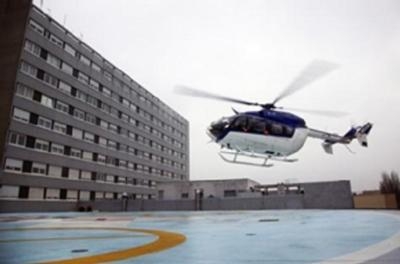
GNSS-SBAS guidance also enhances both the precision and the performance of rotorcraft navigation. In particular, curved procedures enable rotorcraft to operate under IFR in challenging environments such as mountainous areas and to fly safely steep approaches to airports or heliports that are difficult to access or located in densely populated areas. This is particularly important for medical air transport to city hospitals or for helicopter operations in the vicinity of airports without interfering with the surrounding fixed-wing aircraft traffic.
(Image provided by Egis Avia)
More News
Light Gun A handheld directional light signaling device which emits a brilliant narrow beam of white, green, or red light as selected by the tower controller. The color and type of>[...]
"The journey to this achievement started nearly a decade ago when a freshly commissioned Gentry, driven by a fascination with new technologies and a desire to contribute significan>[...]
Aero Linx: JAARS, Inc. For decades now, we’ve landed planes on narrow rivers and towering mountains. We’ve outfitted boats and vehicles to reach villages that rarely se>[...]
"Our driven and innovative team of military and civilian Airmen delivers combat power daily, ensuring our nation is ready today and tomorrow." Source: General Duke Richardson, AFMC>[...]
Aircraft Conflict Predicted conflict, within EDST of two aircraft, or between aircraft and airspace. A Red alert is used for conflicts when the predicted minimum separation is 5 na>[...]
 ANN's Daily Aero-Term (04.20.24): Light Gun

