Mon, Feb 20, 2017
Will Be Employed For A Variety Of Law Enforcement Operations
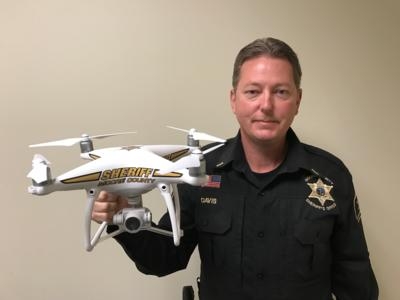
Sheriff Neil Godfrey announced that the Moore County Sheriff’s Office has purchased an Unmanned Aircraft System (UAS) equipped with an eye-in-the-sky camera for surveillance in a variety of law enforcement operations. Three deputies have been trained and have received their FAA and North Carolina certifications which are required for the deputies to fly and operate these types of aircraft legally in North Carolina.
This technological advancement is in concert with the Sheriff’s Office mission by improving the Sheriff Office’s ability to efficiently and effectively enforce the law, protect lives and save valuable resources in time, personnel and money.
“We are not going to be doing random surveillance of people,” Sheriff Godfrey said. “It will be a mission-specific tool to be used for specific incidents.” Those incidents include: search and rescue operations, crime scene photography, documenting natural or man-made disasters, active shooter incidents, searching for a suspect, Special Response Team call-outs, high-risk search warrants, hostage negotiations, drug interdiction, crowd monitoring and explosive-device inspection.
The Sheriff’s Office UAS is a quadcopter with four rotors and has a camera system that will provide officers a real-time video image of what is happening below and around the UAS.
“One of the main uses for the UAS will be for high-risk situations such as someone barricaded in a home or building. The UAS will allow us to get a bird’s-eye view and see more of what’s going on without having to put any of our deputies in danger. The capability will also increase public safety for search and rescue operations. We will no longer have to lose valuable time waiting on helicopters or airplanes to locate missing subjects.” Sheriff Godfrey said.
Lieutenant Tim Davis is heading the program, which falls under the department’s Patrol Division. “We’re really excited,” Lieutenant Davis said. “It’s an amazing piece of technology. The program is going to save lives, resources and time. Everyone in the Sheriff’s Office has supported this and is behind it. And it falls in line with the sheriff’s vision to protect and serve the community with a forward-thinking approach.”
(Image provided with Moore County, NC Sheriff's Office news release)
More News
Aero Linx: Florida Antique Biplane Association "Biplanes.....outrageous fun since 1903." That quote really defines what the Florida Antique Biplane Association (FABA) is all about.>[...]
Beyond Visual Line Of Sight (BVLOS) The operation of a UAS beyond the visual capability of the flight crew members (i.e., remote pilot in command [RPIC], the person manipulating th>[...]
Also: ForeFlight Upgrades, Cicare USA, Vittorazi Engines, EarthX We have a number of late-breaking news highlights from the 2024 Innovation Preview... which was PACKED with real ne>[...]
“For Montaer Aircraft it is a very prudent move to incorporate such reliable institution as Ocala Aviation, with the background of decades in training experience and aviation>[...]
Maximum Authorized Altitude A published altitude representing the maximum usable altitude or flight level for an airspace structure or route segment. It is the highest altitude on >[...]
 ANN's Daily Aero-Linx (04.13.24)

