Sat, Apr 25, 2009
New Software Delivers Interactive Weather Data Over an Internet
Connection
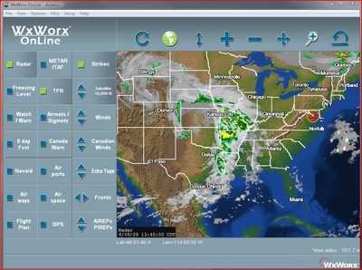
 WxWorx is unveiling WxWorx OnLine, a new, fully interactive
graphical weather software for daily weather monitoring and
pre-flight weather analysis across the United States and Canada.
Providing timely and accurate weather information directly to the
user's PC, WxWorx OnLine connects to the internet and delivers
high-resolution NEXRAD radar coverage, winds aloft, METARs,
lightning and more - all in one easy-to-use application. Available
for installation on the user's compatible PCs, WxWorx OnLine will
only enable one connection at a time per user. The software is
available as a free download from the WxWorx store and requires an
affordable monthly data subscription to WxWorx OnLine's Aviation
package.
WxWorx is unveiling WxWorx OnLine, a new, fully interactive
graphical weather software for daily weather monitoring and
pre-flight weather analysis across the United States and Canada.
Providing timely and accurate weather information directly to the
user's PC, WxWorx OnLine connects to the internet and delivers
high-resolution NEXRAD radar coverage, winds aloft, METARs,
lightning and more - all in one easy-to-use application. Available
for installation on the user's compatible PCs, WxWorx OnLine will
only enable one connection at a time per user. The software is
available as a free download from the WxWorx store and requires an
affordable monthly data subscription to WxWorx OnLine's Aviation
package.
"Our customers requested a weather solution that they could use
with any wireless or wired internet connection," said Bob Baron,
president and CEO of WxWorx. "Perfect as a part of pre-flight
planning, WxWorx OnLine gives pilots the ability to check weather
conditions even before they leave home."
WxWorx OnLine's intuitive interface enables aviators to quickly
and easily view and interact with weather data at any point on the
map by zooming into areas of interest to see greater detail. Since
weather conditions significantly affect aircraft performance,
WxWorx OnLine provides weather information in one consolidated
location for daily weather monitoring. Utilizing a Global
Positioning System (GPS) device, pilots can check weather
conditions in relation to their precise location, providing
enhanced situational awareness.
WxWorx OnLine's data package, Aviation, is being offered at an
affordable rate of just $24.99 per month with no contract required,
or $19.99 per month with a one-year subscription that is paid in
full. The Aviation package contains a complete suite of weather
products including:
- High Resolution NEXRAD Radar
- High Resolution Canadian Radar
- Radar Coverage
- Precipitation Type (at surface)
- City Forecasts
- TFRs
- METARs
- TAFs
- County Warnings
- Canadian Weather Warnings
- Winds Aloft (at altitude)
|
- Lightning
- AIRMETs
- SIGMETs
- Echo Tops
- Freezing Level
- Severe Weather Storm Tracks
- Surface Analysis Weather Maps
- Satellite Mosaic
- AIREPs
- PIREPs
- SPC Aviation Weather Watches
|
WxWorx OnLine is immediately available as a free download, or a
software CD can be purchased for $10.00 plus shipping. A Windows
2000, XP, Vista or Tablet PC operating system with Pentium-class
processing of 800 megahertz (MHz) or higher, 512 megabytes (MB) of
RAM and 350 MB of hard-disk space are required for running WxWorx
OnLine.
More News
Maximum Authorized Altitude A published altitude representing the maximum usable altitude or flight level for an airspace structure or route segment. It is the highest altitude on >[...]
Aero Linx: Soaring Safety Foundation (SSF) The Soaring Safety Foundation (SSF) is the Training and Safety arm of the Soaring Society of America (SSA). Our mission is to provide ins>[...]
From 2013 (YouTube Version): Dracula Lives On Through Kyle Franklin... and We're NOT Scared! ANN CEO and Editor-in-Chief, Jim Campbell speaks with Aerobatic and airshow master, Kyl>[...]
“For Montaer Aircraft it is a very prudent move to incorporate such reliable institution as Ocala Aviation, with the background of decades in training experience and aviation>[...]
Also: ForeFlight Upgrades, Cicare USA, Vittorazi Engines, EarthX We have a number of late-breaking news highlights from the 2024 Innovation Preview... which was PACKED with real ne>[...]
 ANN's Daily Aero-Term (04.14.24): Maximum Authorized Altitude

