Jeppesen Standardizes Runway Incursion 'Hot Spot' Depictions | Aero-News Network
Aero-News Network
RSS icon RSS feed
podcast icon MP3 podcast
Subscribe Aero-News e-mail Newsletter Subscribe

Airborne Unlimited -- Most Recent Daily Episodes

Episode Date

Airborne-Monday

Airborne-Tuesday

Airborne-Wednesday Airborne-Thursday

Airborne-Friday

Airborne On YouTube

Airborne-Unlimited-04.01.24

Airborne-Unlimited-04.16.24

Airborne-FlightTraining-04.17.24 Airborne-Unlimited-04.11.24

Airborne-Unlimited-04.12.24

Join Us At 0900ET, Friday, 4/10, for the LIVE Morning Brief.
Watch It LIVE at
www.airborne-live.net

Thu, May 17, 2007

Jeppesen Standardizes Runway Incursion 'Hot Spot' Depictions

Magenta Means "Be Extra Cautious"

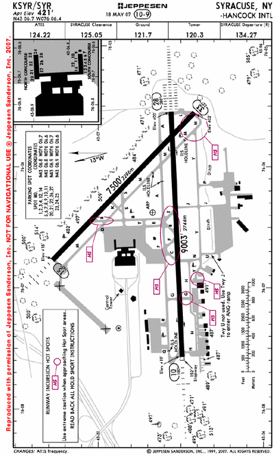
In an effort to help bring additional awareness to the ongoing issue of runway incursions, Jeppesen tells ANN the company recently began the process of depicting runway incursion hot spots in a standardized magenta color on certain airport diagrams in the worldwide library.

Hot spots on paper charts will be converted from gray to the magenta depiction as they are revised, thus making them easier for pilots to identify. Jeppesen electronic charts have displayed hot spots in red for some time, but in the summer 2007 these too will be switched to the now Jeppesen standard magenta color. The affected electronic charts will be switched all at once.

Airport hot spots are designated at airports by aeronautical authorities around the world and are intended to heighten awareness of areas on an airport surface that could cause positional awareness confusion for pilots. Jeppesen depicts hot spots with the designator “HS1, HS2, HS3...” and a magenta circle around the region. Often hot spots exist at airports with many intersecting taxiways and runways, and/or complex ramp areas. 

“Runway incursions continue to be a safety concern for the aviation industry,” said Mark Van Tine, Jeppesen president and COO. “By standardizing the way runway incursion hot spots are depicted on our charts we aim to increase awareness among pilots by making the hot spots a prominent, easily identifiable chart feature. Jeppesen is also taking proactive steps to improve positional awareness on the ground through our digital Airport Moving Map application that provides pilots a very detailed rendering of airport surface features along with an aircraft position spotter.”

Jeppesen is a subsidiary of Boeing Commercial Aviation Services, a unit of Boeing Commercial Airplanes.

FMI: www.jeppesen.com

Advertisement

More News

ANN's Daily Aero-Linx (04.15.24)

Aero Linx: International Flying Farmers IFF is a not-for-profit organization started in 1944 by farmers who were also private pilots. We have members all across the United States a>[...]

Classic Aero-TV: 'No Other Options' -- The Israeli Air Force's Danny Shapira

From 2017 (YouTube Version): Remembrances Of An Israeli Air Force Test Pilot Early in 2016, ANN contributor Maxine Scheer traveled to Israel, where she had the opportunity to sit d>[...]

Aero-News: Quote of the Day (04.15.24)

"We renegotiated what our debt restructuring is on a lot of our debts, mostly with the family. Those debts are going to be converted into equity..." Source: Excerpts from a short v>[...]

Airborne 04.16.24: RV Update, Affordable Flying Expo, Diamond Lil

Also: B-29 Superfortress Reunion, FAA Wants Controllers, Spirit Airlines Pulls Back, Gogo Galileo Van's Aircraft posted a short video recapping the goings-on around their reorganiz>[...]

ANN's Daily Aero-Term (04.16.24): Chart Supplement US

Chart Supplement US A flight information publication designed for use with appropriate IFR or VFR charts which contains data on all airports, seaplane bases, and heliports open to >[...]

blog comments powered by Disqus


Advertisement

Advertisement

Podcasts

Advertisement

© 2007 - 2024 Web Development & Design by Pauli Systems, LC