China Denies Reports It Faked Lunar Photo | Aero-News Network
Aero-News Network
RSS icon RSS feed
podcast icon MP3 podcast
Subscribe Aero-News e-mail Newsletter Subscribe

Airborne Unlimited -- Most Recent Daily Episodes

Episode Date

Airborne-Monday

Airborne-Tuesday

Airborne-Wednesday Airborne-Thursday

Airborne-Friday

Airborne On YouTube

Airborne-Unlimited-04.01.24

Airborne-Unlimited-04.16.24

Airborne-FlightTraining-04.17.24 Airborne-Unlimited-04.11.24

Airborne-Unlimited-04.12.24

Join Us At 0900ET, Friday, 4/10, for the LIVE Morning Brief.
Watch It LIVE at
www.airborne-live.net

Tue, Dec 04, 2007

China Denies Reports It Faked Lunar Photo

Says Chang'e Image Has Two Craters, US Image Has One

Chinese officials deny an Internet rumor the first photo of the lunar surface from its Chang'e orbiter may have been plagiarized from NASA, according to Reuters.

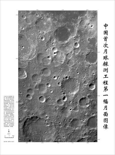
China launched its first lunar probe, the Chang'e 1, in October. As ANN reported, Chinese officials released a detailed image (above) of the moon's cratered surface last week, hailing the mission as a "1000-year-old dream come true."

However, some Chinese Internet buffs say the image is almost identical to a 2005 lunar image from the National Aeronautics and Space Administration.

"There is absolutely no forgery," said Ouyang Ziyuan, the lunar probe's chief scientist.

Ziyuan asserts the similarities between the two images is due to the fact both probes aimed at the same area, the moon's southern hemisphere.

"But a careful examination will tell some small differences," Ouyang said. For example, he says, the Chinese photo showed two craters in a certain spot; the US image showed only one on the same spot, according to a Beijing News report.

"Maybe it's because the resolution of the American photo was not high enough or a new pit might have been generated by an asteroid hitting the moon between 2005 and 2007," Ouyang said.

"I understand the doubts of the Internet surfers. They hope the Chinese lunar probe can do well so they don't want the photo to turn out to be fake," he said.

A new three-dimensional image of the lunar surface from Chang'e 1 was made available on Sunday, as well some new data received from the satellite will be offered to the public soon.

The Chinese space program's ambitious plan is to offer scientific and military benefits, as well as create additional credibility for the nation.

China became only the third country to put a man into space using its own rocket in 2003, after the former Soviet Union and the United States. Later it sent two astronauts on a five-day flight on its Shenzhou VI mission in October 2005.

A third manned mission, Shenzhou VII, will launch next year that is scheduled to involve a space walk.

It appears that an Asian space race is on as other countries have also announced lunar plans. Japan shot its first lunar satellite into space in September and India plans for its satellite launch in 2008.

FMI: www.cnsa.gov.cn/n615709/cindex.html

Advertisement

More News

ANN's Daily Aero-Linx (04.15.24)

Aero Linx: International Flying Farmers IFF is a not-for-profit organization started in 1944 by farmers who were also private pilots. We have members all across the United States a>[...]

Classic Aero-TV: 'No Other Options' -- The Israeli Air Force's Danny Shapira

From 2017 (YouTube Version): Remembrances Of An Israeli Air Force Test Pilot Early in 2016, ANN contributor Maxine Scheer traveled to Israel, where she had the opportunity to sit d>[...]

Aero-News: Quote of the Day (04.15.24)

"We renegotiated what our debt restructuring is on a lot of our debts, mostly with the family. Those debts are going to be converted into equity..." Source: Excerpts from a short v>[...]

Airborne 04.16.24: RV Update, Affordable Flying Expo, Diamond Lil

Also: B-29 Superfortress Reunion, FAA Wants Controllers, Spirit Airlines Pulls Back, Gogo Galileo Van's Aircraft posted a short video recapping the goings-on around their reorganiz>[...]

ANN's Daily Aero-Term (04.16.24): Chart Supplement US

Chart Supplement US A flight information publication designed for use with appropriate IFR or VFR charts which contains data on all airports, seaplane bases, and heliports open to >[...]

blog comments powered by Disqus


Advertisement

Advertisement

Podcasts

Advertisement

© 2007 - 2024 Web Development & Design by Pauli Systems, LC