NASA Supports UAS Fire Mapping Efforts In CA Fire | Aero-News Network
Aero-News Network
RSS icon RSS feed
podcast icon MP3 podcast
Subscribe Aero-News e-mail Newsletter Subscribe

Airborne Unlimited -- Most Recent Daily Episodes

Episode Date

Airborne-Monday

Airborne-Tuesday

Airborne-Wednesday Airborne-Thursday

Airborne-Friday

Airborne On YouTube

Airborne-Unlimited-04.22.24

Airborne-Unlimited-04.16.24

Airborne-FlightTraining-04.17.24 Airborne-AffordableFlyers-04.18.24

Airborne-Unlimited-04.19.24

Join Us At 0900ET, Friday, 4/10, for the LIVE Morning Brief.
Watch It LIVE at
www.airborne-live.net

Tue, Nov 07, 2006

NASA Supports UAS Fire Mapping Efforts In CA Fire

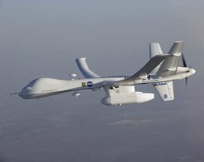
Altair Unmanned Plane Snaps Photos Of Fatal Arson Blaze

Here's a definite example of the good that unmanned aerial vehicles (UAVs) can do in dangerous situations. Aero-News has learned a team led by NASA and US Forest Service scientists recently collected real-time, visible and infrared data from sensors onboard a remotely piloted aircraft over the Esperanza Fire in Southern California.

The Esperanza Fire, an arson-set fire that claimed the lives of five firefighters, was ignited on Thursday, October 26. Whipped by powerful Santa Ana winds, it spread over 40,200 acres, or roughly 62 square miles, destroying 34 homes and 20 other structures.

The California Governor's Office of Emergency Services and the Esperanza Fire Incident Command Center requested NASA's imaging and fire mapping assistance.

The Altair Unmanned Aircraft System -- built and operated by General Atomics Aeronautical Systems Inc. of San Diego, CA -- was prepared to fly in less than 24 hours. The flight was facilitated by the Federal Aviation Administration, which assures the safety of unmanned aircraft system flights in the National Airspace System.

Recent changes to the FAA's organizational structure allowed the approval to be expedited, while ensuring no degradation of safety and without imposing any new temporary flight restrictions.

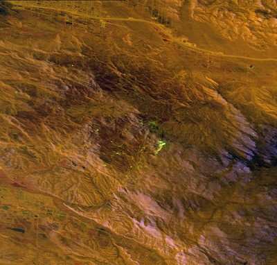
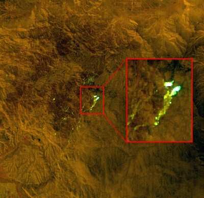
From an altitude of 43,000 feet, the wildfire sensor collected and sent 100 images and more than 20 data files containing the location of the fire perimeter over a 16-hour period on October 28 and 29. The data were delivered in real time through a satellite communications link. NASA and Forest Service specialists worked to familiarize the fire management team with accessing capabilities and sensor data format. The data from the NASA system were used by the Esperanza Fire Incident Command Center to map fire behavior and direct resources to critical areas on the fire.

The flight project was sponsored and funded by NASA's Science Mission Directorate. The team consisted of NASA's Ames Research Center, Moffett Field, CA; NASA's Dryden Flight Research Center, Edwards, CA; The National Interagency Fire Center, Boise, ID; US Forest Service Remote Sensing Laboratory, Salt Lake City, UT; California Governor's Office of Emergency Services; California Department of Forestry and Fire Protection, Sacramento, CA; and General Atomics Aeronautical Systems Inc.

FMI: www.ga-asi.com/, http://nirops.fs.fed.us/UASDemo/

Advertisement

More News

ANN's Daily Aero-Term (04.20.24): Light Gun

Light Gun A handheld directional light signaling device which emits a brilliant narrow beam of white, green, or red light as selected by the tower controller. The color and type of>[...]

Aero-News: Quote of the Day (04.20.24)

"The journey to this achievement started nearly a decade ago when a freshly commissioned Gentry, driven by a fascination with new technologies and a desire to contribute significan>[...]

ANN's Daily Aero-Linx (04.21.24)

Aero Linx: JAARS, Inc. For decades now, we’ve landed planes on narrow rivers and towering mountains. We’ve outfitted boats and vehicles to reach villages that rarely se>[...]

Aero-News: Quote of the Day (04.21.24)

"Our driven and innovative team of military and civilian Airmen delivers combat power daily, ensuring our nation is ready today and tomorrow." Source: General Duke Richardson, AFMC>[...]

ANN's Daily Aero-Term (04.21.24): Aircraft Conflict

Aircraft Conflict Predicted conflict, within EDST of two aircraft, or between aircraft and airspace. A Red alert is used for conflicts when the predicted minimum separation is 5 na>[...]

blog comments powered by Disqus


Advertisement

Advertisement

Podcasts

Advertisement

© 2007 - 2024 Web Development & Design by Pauli Systems, LC