JPL Releases Photos Of Haiti Fault Lines | Aero-News Network
Aero-News Network
RSS icon RSS feed
podcast icon MP3 podcast
Subscribe Aero-News e-mail Newsletter Subscribe

Airborne Unlimited -- Most Recent Daily Episodes

Episode Date

Airborne-Monday

Airborne-Tuesday

Airborne-Wednesday Airborne-Thursday

Airborne-Friday

Airborne On YouTube

Airborne-Unlimited-04.01.24

Airborne-Unlimited-04.16.24

Airborne-FlightTraining-04.17.24 Airborne-Unlimited-04.11.24

Airborne-Unlimited-04.12.24

Join Us At 0900ET, Friday, 4/10, for the LIVE Morning Brief.
Watch It LIVE at
www.airborne-live.net

Thu, Feb 04, 2010

JPL Releases Photos Of Haiti Fault Lines

Scientists Hope To Be Able To Measure Tectonic Plate Movements

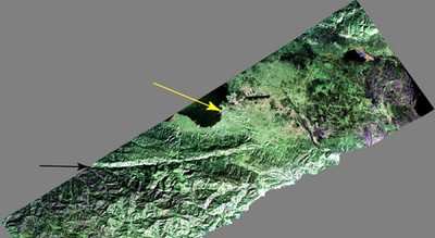
JPL's Uninhabited Aerial Vehicle Synthetic Aperture Radar (UAVSAR) captured this false-color composite image of the city of Port-au-Prince, Haiti, and the surrounding region on Jan. 27, 2010. Port-au-Prince is visible near the center of the image. The large dark line running east-west near the city is the main airport. UAVSAR left NASA's Dryden Flight Research Center in Edwards, CA, January 25, aboard a modified NASA Gulfstream III aircraft on a three-week campaign that will also take it to Central America.


Photo Courtesy JPL

Shortly before 1700 local time on January 12,a magnitude 7.0 earthquake struck southern Haiti. The earthquake's epicenter was about 25 kilometers (15 miles) west-southwest of Port-au-Prince, close to the west (left) edge of this image (yellow arrow). The large linear east-west valley in the mountains south of the city is the location of the major active fault zone responsible for the earthquake: the Enriquillo-Plantain Garden fault (black arrow). The fault extends from the western tip of Haiti past Port-au-Prince into the Dominican Republic to the east of this image. Historical records show that the southern part of Haiti was struck by a series of large earthquakes in the 1700s, and geologists believe those were also caused by ruptures on this fault zone.

Satellite interferometric synthetic aperture radar measurements show that the January 12 earthquake ruptured a segment of the fault extending from the epicenter westward over a length of about 40 kilometers (25 miles), leaving the section of the fault in this image unruptured. The earthquake has increased the stress on this eastern section of the fault south of Port-au-Prince and the section west of the rupture. This has significantly increased the risk of a future earthquake, according to a recent report by the U.S. Geological Survey.

This image will be combined with other images of the same area to be acquired later this month and in the future in order to measure the motion of Earth's surface during the time between images using a technique called interferometry.The interferometric measurements will allow scientists to study the pressures building up and being released on the fault at depth.

FMI: http://uavsar.jpl.nasa.gov/

Advertisement

More News

ANN's Daily Aero-Linx (04.15.24)

Aero Linx: International Flying Farmers IFF is a not-for-profit organization started in 1944 by farmers who were also private pilots. We have members all across the United States a>[...]

Classic Aero-TV: 'No Other Options' -- The Israeli Air Force's Danny Shapira

From 2017 (YouTube Version): Remembrances Of An Israeli Air Force Test Pilot Early in 2016, ANN contributor Maxine Scheer traveled to Israel, where she had the opportunity to sit d>[...]

Aero-News: Quote of the Day (04.15.24)

"We renegotiated what our debt restructuring is on a lot of our debts, mostly with the family. Those debts are going to be converted into equity..." Source: Excerpts from a short v>[...]

Airborne 04.16.24: RV Update, Affordable Flying Expo, Diamond Lil

Also: B-29 Superfortress Reunion, FAA Wants Controllers, Spirit Airlines Pulls Back, Gogo Galileo Van's Aircraft posted a short video recapping the goings-on around their reorganiz>[...]

ANN's Daily Aero-Term (04.16.24): Chart Supplement US

Chart Supplement US A flight information publication designed for use with appropriate IFR or VFR charts which contains data on all airports, seaplane bases, and heliports open to >[...]

blog comments powered by Disqus


Advertisement

Advertisement

Podcasts

Advertisement

© 2007 - 2024 Web Development & Design by Pauli Systems, LC